Update From the Arctic #6: Mission Accomplished

CWF’s Larry Niles is in Northern Canada searching for Red Knots and other shorebirds in their Arctic breeding territory. We are following him and posting summaries of his blog entries as he reports from the field.


Our small camp. The cold weather and frigid rain confined us to our tents on our second-to-last day.
Our small camp. The cold weather and frigid rain confined us to our tents on the second-to-last day of our trip.

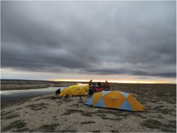
Our second-to-last day in the Arctic was rained out. A constant cold drizzle punctuated by brief downpours confined us to our tents, as the limited visibility would have made it impossible to spot Red Knots or their nests – or approaching polar bears.


We saw our first ( and last ) polar bear on the final day of the trip.  When it saw us coming his way, he slowly lumbered off in the opposite direction, posing no threat.
We saw our first (and last) polar bear on the final day of the trip. When it saw us coming his way, he slowly lumbered off in the opposite direction, posing no threat.

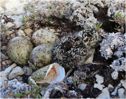
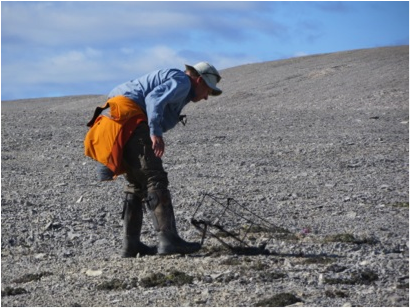
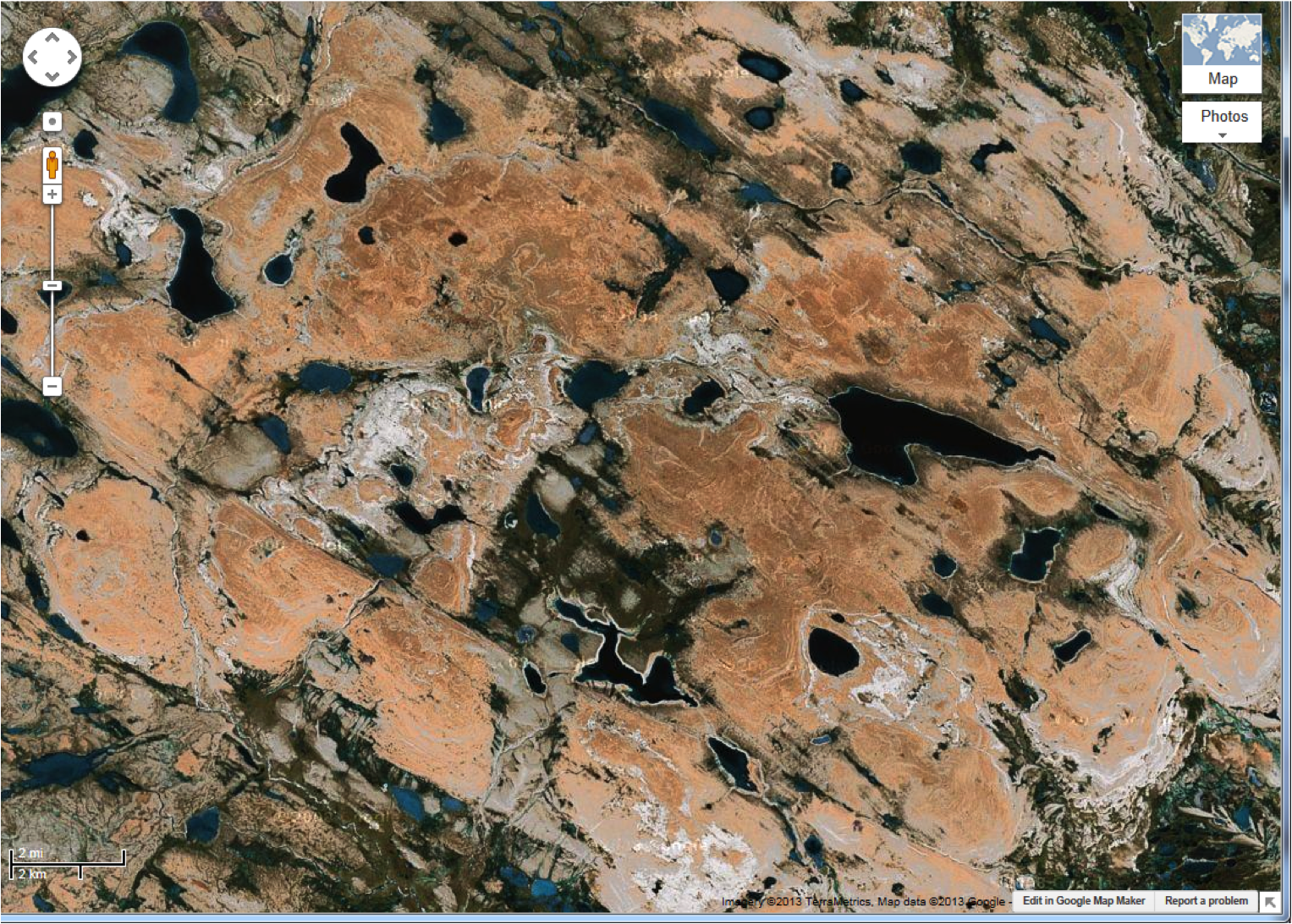
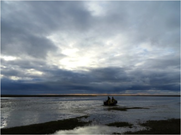
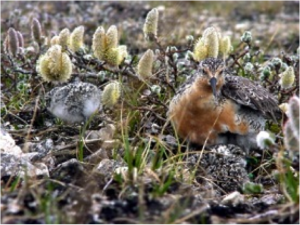
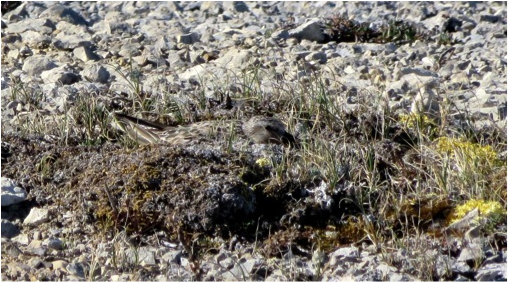
But on our last day on Knot Plateau, we woke to a brilliant sunny day. While Rick, Steve, and Mandy broke camp, Josh, Mark, and I drove our ATVs out to the two knot nests we had found two days prior. As we had only banded one parent at each nest, we were hoping to find the unbanded birds this time. But the newly hatched knots and their parents had already left for the nearest wetland, and the incubating bird on the second nest was the bird already tagged with a geolocator. With nothing more to be done, we made our way back to camp to help finish packing.


A knot incubates her eggs on a small patch of vegetation.

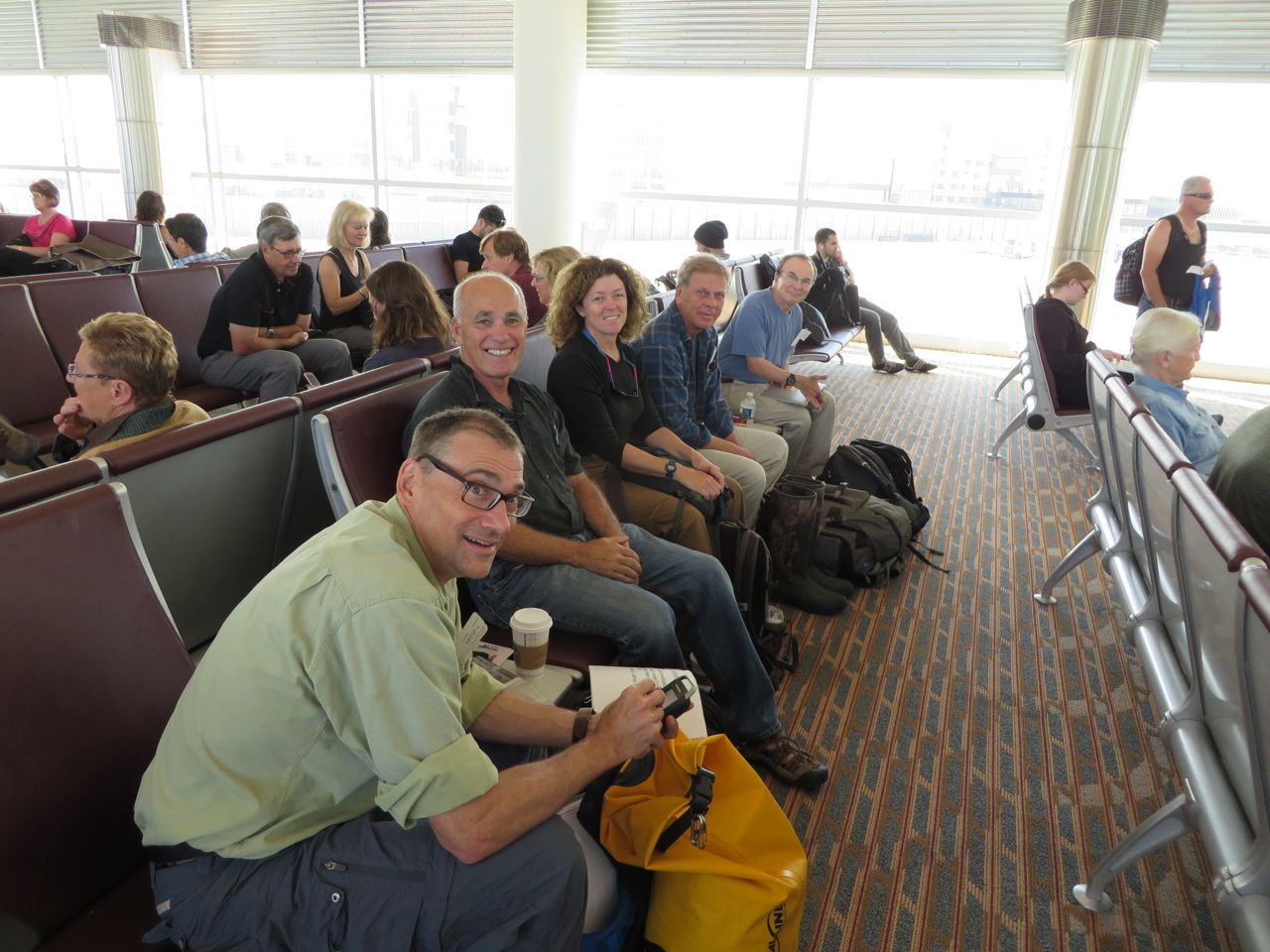
It took two days to return to Coral Harbour and civilization. After staying the night with Josh and his family, we will begin our two-day journey by commercial flight back to Newark, anticipating the shift from 45 degrees to 95 degrees, but glad to be coming home.


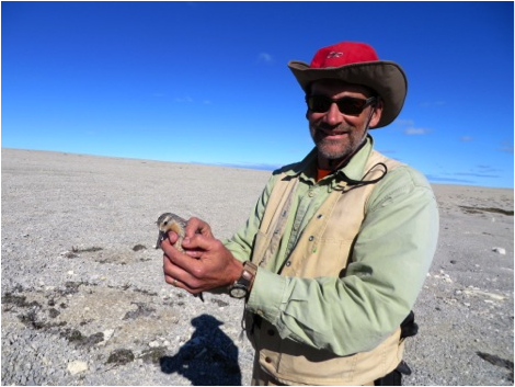
The expedition was a success simply because we are all coming home safe and sound. But it was also a complete success because we achieved all of our primary goals. First, we established the presence of a new Red Knot breeding area from the ground. Second, we found a significant number of knots compared to our previous study sites on both Southampton and King William Islands, where most of the knot population had disappeared after the rapid decline in stopovers like Delaware Bay. Third, we finished the fieldwork needed to complete our range-wide mapping of rufa knot breeding habitat, which will help future investigations into Red Knot ecology. And finally, we attached the first geolocators to knots in the Canadian Arctic and set a firm foundation for a more successful effort in the future.


Our Team. Back row, L to R: Larry Niles and Mandy Dey. Front row, L to R: Mark Peck, Joshua Keenainak, Steve Gates, and Rick Lathrop.
Our team. Back row, L to R: Larry Niles and Mandy Dey. Front row, L to R: Mark Peck, Joshua Keenainak, Steve Gates, and Rick Lathrop.

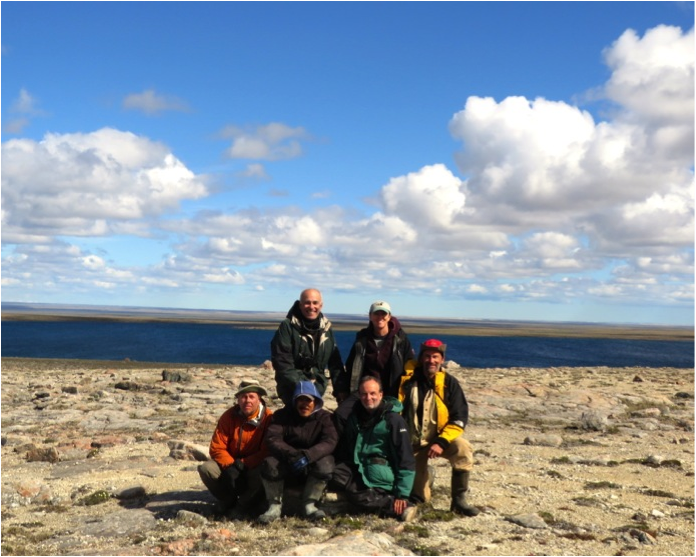
We are grateful to many people. The expedition would have been impossible without the support of Paul Smith of the Canadian Wildlife Service. The Conserve Wildlife Foundation of NJ, the Canadian Wildlife Service, Rutgers University, the Royal Ontario Museum, and The Steve Gates and Julie Fox Foundation all supported the expedition. The Coral Harbour Hunters and Trappers Organization provided essential support. Bruce McKitrick helped us with supplies. Finally we thank Joshua, Suzy, and their family for their hospitality. This expedition was only successful because of all of you.


For the full blog entries, see Larry’s posts: Arctic Rain, Our Last Day, and Summing Up Our 2013 Arctic Expedition.


Update from the Arctic #5: Knots at Last

CWF’s Larry Niles is in Northern Canada searching for Red Knots and other shorebirds in their Arctic breeding territory. We are following him and posting summaries of his blog entries as he reports from the field.


The first nest we found had one hatched chick, so fresh you can still see the embryonic material in the shell.
The second nest we found was on the side of an almost completely barren hill.

After 10 days in the field, 5 of them searching for knots, and with only one day before we must leave, we have at long last found knot nests – two, in fact. As we suspected, both still contained eggs, although one adult was also brooding a chick that was only hours old. Also as we suspected, we found them on small ridges in gravel-sized frost-cracked rock with very sparse vegetation.


Mark sets the trap to catch the nesting adult knot. The trap falls when the bird sits on a small line across the nest.

There are fewer knots than the number of potential knot nesting sites in our study area, meaning the knots have two possible strategies when they choose a nesting site: they could be fanning out at very low densities, or they could be clustering and keeping a certain distance apart. Our experience at our first red knot study site suggested the latter possibility. In the first few years, when knot populations were still fairly high, knots occurred along ridges one kilometer apart. This fell apart as the number of knots collapsed in the period between 1999 to 2006, but our experience suggested knots will stay together and keep territories of about one square kilometer. In other words, knots like their space, but they still want neighbors.


So after finding the first nest, we started searching about 1 km away in adjacent habitat and soon found a second nest, corroborating our theory. But by then it was close to the end of the day and we had only an hour or so to search for a third. Finding none, we rode the 4 miles of hard trail back to camp with some satisfaction. We will try again tomorrow to find more in the area, but unfortunately it will be our last day.


A geolocator, about to be attached to a knot

Rain is falling against our tent, as it has through most of the night. Rain in the Arctic is always cold – more of a winter rain than one of summer. The knot nest with one chick will almost certainly have four by now, as it usually only takes 24 hours for all eggs to hatch. The adult will brood the chicks as best he can, but it’s not unusual for weather such as this to kill young shorebirds. This is one of many reasons why northbound stopovers like Delaware Bay must provide shorebirds with a good start every year.


Rick released the knots at their nests.

If the rain abates, we will continue searching for nests tomorrow, but only time will tell whether our final day in the field will be a washout. Regardless, it is a wonderful feeling to have finally found what we came searching for.


For the full blog entry, see Larry’s post here.

Stay tuned for further updates!


Update from the Arctic #4: Knot Plateau

CWF’s Larry Niles is in Northern Canada searching for Red Knots and other shorebirds in their Arctic breeding territory. We are following him and posting summaries of his blog entries as he reports from the field.


Arctic Fox are one of the top predators of shorebird eggs. A mottled brown color in the summer, their fur turns snow white every winter.

Our camp here on knot plateau is spartan. We had to jettison many of the luxury items, like the cook tent, so that we would need to make the 25-mile ATV trip into the plateau only once. Even then, the ATVs were overloaded, and we had numerous problems like flat tires and a cracked support for the back rack.

Josh’s skills have proven invaluable, as he has repaired our ATVs multiple times. Here, he fixes a slice in an ATV’s tire from a sharp rock.


At this point in our trip, the rigors of conducting daily field work and sleeping on therm-a-rest mattresses in unheated, low-ceilinged tents are starting to wear us out. Of course, much of this is age-related. The author of this blog, being on the older side of the crew, finds the need to get dressed in a tent the size of a refrigerator box to be the most difficult part of our field experience. Ironically Joshua, the youngest of our crew, has a small campaign tent in which he can stand.


A typical ridge nesting habitat on knot plateau.

But complications such as these are minor compared to what we have discovered: numbers of knots at least equal to the high densities we saw years ago. Better yet, the amount of potential nesting habitat on knot plateau is far greater than other Arctic sites we have surveyed because the knots here are nesting in much greater profusion. This plateau is perfect nesting habitat because these potential nesting sites are surrounded by wetlands where the newly-hatched young can feed, and the complex is also within 10 kilometers of the Sutton River basin. The river remains clear almost year-round, making it a perfect feeding spot for the adults while the nesting area is still frozen.

Team member Mark Peck examines an unhatched American Golden Plover nest.


The greater area of habitat, however, causes great difficulty in finding nests, and it doesn’t help that knot nests are the notoriously hard to locate to begin with. Most shorebirds react to intruders on approach because both adults stay near the nest. But Red Knots, on the other hand, don’t react to intruders because one adult is elsewhere feeding and the incubating bird won’t leave the nest until he is almost stepped on. So far, we have found the nests of several shorebird species such as American Golden Plover, Semipalmated Sandpiper, and Dunlin, as well as those of other birds like Long-tailed Jaegers – but so far no knot nests.


A Google Earth image of our study area.
An interpreted map of the same area. Each color represents a different level of desirability for Red Knots.

Our mapping work is going well and may yet prove the most valuable result of this trip. Under Rick’s guidance we are ground truthing interpreted satellite images that already distinguish tundra habitat with good precision. Our task is to train the map to distinguish habitat important to knots. In the end we will create a precise mapping of optimal knot habitat.


All in all, we still have a lot of work to do and not much time left to do it. But even though we have yet to find the knot nests we came for, we cannot help but be pleased by what we have already found.


For the original blog entries, see Larry’s posts Knot Plateau and The Search Continues.

Stay tuned for further updates!


Update from the Arctic #3: Roadless Tundra and River Crossings

CWF’s Larry Niles is in Northern Canada searching for Red Knots and other shorebirds in their Arctic breeding territory. We are following him as he reports from the field. The following is a summary of his latest blog posts.

Our camp along the Sutton River.


It has been a grueling, but exhilarating, last few days for our team. At long last, we’ve reached our study site. Anyone else would have looked at this barren plateau and wondered what all the fuss was about, but our team fist-bumped with pride. After three tries, we had finally made it – but getting here was an arduous process we won’t soon forget.


Once into the formidable wetland of the Sutton River, our machines frequently sank up to the axles in mud. We spent most of the day trying to cross the wetland, but couldn’t. And all the while, we had to keep watch for bears.
Once into the formidable wetland of the Sutton River, our machines frequently sank up to the axles in mud. And all the while, we had to keep watch for bears.

We left Coral Harbour on Wednesday afternoon with three ATVs and a truck, as well as a new team member. Josh is our “bear-watcher,” an experienced Inuit hunter whose job is to discourage or, if absolutely necessary, kill an attacking polar bear. We can only hope his services will not be required.


Rick Lathrop uses both topographic maps and satellite imagery to help guide us through this tundra wilderness. Next to Rick, our 3 ATVs are packed with 10 days' worth of supplies for 6 people.
Rick Lathrop uses both topographic maps and satellite imagery to help guide us through this tundra wilderness. Next to Rick, our 3 ATVs are packed with 10 days’ worth of supplies for 6 people.

We had hoped that the road out of town, which was recently extended, might take us all the way to our study site – but it was not to be. Four hours after leaving Coral Harbour, we reached a point where we had to depart from the road and traverse out into the roadless tundra.


We set out by ATV the next morning, but soon ran into trouble. To get to the knot plateau, we had to cross the Sutton River, one of Southampton Island’s major rivers. It’s a gentle stream where it crosses the road, but at the place where we needed to cross it was a wide valley, within which lay one of the most formidable wetlands in the Arctic. The ground shook like Jell-O as we walked, and if an ATV so much as scratched the surface it was down to its axles. After five hours, we had to give up.

Making one of four attempts to cross the Sutton River.


At Josh’s suggestion, the next day we travelled about 15 miles downriver to a crossing used by Inuit hunters. The river was wider there, but we were optimistic because the riverbank was high ground, so we could drive up or downriver over easily-traversed terrain. But after four attempts with the ATV, we could see the river was too deep to cross. The knot plateau was within sight on the other side, but for a second time we had to drive away.


spent
After several days of trying to cross the treacherous Sutton River, we were spent.

Finally, Rick found an almost entirely dry ridge of high ground about three miles to the west of our camp. After crossing the Sutton River near its headwaters, it was five hours of rough riding with fully-loaded ATVs along the ridge to get back to the knot plateau. When the plateau finally rose up before us, we were elated. We drove six more miles before finally setting camp along one of the many lakes in the complex.


Thankfully, water is not an issue. One of the joys in the Arctic is the clear ice melt water almost everywhere. Here, Mark collects water from the Sutton in an Arctic sunset.

The big question we will answer tomorrow is: do knots still use this area? In 1999, there were at least four times as many knots as there were three years ago, following the collapse of the Delaware Bay horseshoe crab population. Knots have disappeared entirely from many areas of the Arctic – are they still here? We shall find out tomorrow.


For the original blog entries, see Larry’s posts: Polar Bears and Roadless Tundra, On to the Land, River Crossings, and Third Time’s a Charm.

Stay tuned for further updates!


Update from the Arctic #2: In Search of Knots

CWF’s Larry Niles is in Northern Canada searching for Red Knots and other shorebirds in their Arctic breeding territory. We are following him and posting summaries of his blog entries as he reports from the field.


A Semipalmated Sandpiper nesting in wetland tundra on Southampton Island.

While flying from Winnipeg to Nunavut, we focused on a strategy for finding red knot nests and adults with broods. We know from our 9 years of Arctic work that knots don’t occur randomly across the tundra landscape. Quite the opposite, they choose very specific places that distinguish knots from other Arctic nesting shorebirds.


Eskers and frozen wetlands are typical knot nesting habitat on Southampton Island. In only a few weeks, the snow will be mostly gone and the wetlands will produce insect forage for knots.

Most knots choose to nest in relatively barren tundra slightly higher in elevation than more common Arctic nesting shorebirds. The latter prefer the lush wetland tundra along the coast and in the bigger river drainages because of the abundant prey early in the season. So why are knots drawn to colder and more barren places? We suspect they rely on the more persistent snow cover to discourage predation while they lie low in small patches of snow-free patches. Most predators prefer the lush areas with relatively dense shorebird nests. By the time the knot young hatch and are ready to feed, the protective snow barrier melts and the adults take their brood to the surrounding defrosted wetlands. By then shorebird prey are abundant.


So we suspect that at this point in the nesting season, we will find eggs just starting to hatch and soon the adults will lead their young to the nearby wetlands. Rick Lathrop, head of the Rutgers University Center for Remote Sensing and Spatial Analysis (CRSSA), has prepared mapping that will help us find prospective nest sites with the following characteristics:

  1. Areas with less than 5% vegetation (We will especially be looking for eskers, or sinuous frost-cracked rocky ridges that snake through the best knots habitats.)
  2. Numerous nearby patches of wetlands or small lakes with interconnecting streams
  3. Areas of slightly higher elevation that stay snowy longer into the season


Map prepared by Rick Lathrop of CRSSA lab at Rutgers, indicating prime areas to search for knots and their broods.

We have several targets but we are not certain that we can get to them. We hope to drive into the interior areas of Southampton on a new road built to help residents access new fishing sites. We want to take a truck as far as possible to carry our supplies and equipment. At the road end we will still have to move everything with ATVs to the areas of greatest probability, which are likely to be about 10-20 miles off the new road. It’s hard to plan.


But the rewards are great. If we are successful we will be able to study red knot for the first time without the need of being flown in to a remote place at great expense. We shall see.


For the original blog entry, see Larry’s post here.

Stay tuned for further updates!

Update from the Arctic: News from Our Shorebird Scientists

CWF’s Larry Niles and his colleagues left yesterday on a three-week trip to Northern Canada to search for the nests of Red Knots and other shorebirds in their Arctic breeding territory. We’ll be following him and posting summaries of his blog entries as he reports from the field.


A red knot with his brood of chicks.

The odd thing about the shorebirds of Delaware Bay is that they are not really of Delaware Bay but of the Canadian Arctic. The most important part of their lives is spent in the barren high tundra of the Arctic, in places like Southampton Island, located on the north end of Hudson Bay. We have worked in Southampton Island for 6 years studying the red knot but stopped because the decline seen in Delaware Bay was more than apparent in the Arctic – birds literally disappeared from our study site.


Map of red knot 1VL developed from a geolocator when recaptured on Delaware Bay. 1VL nested on Southampton Island.

It’s been 8 years since then, and now we are returning to begin new research on red knots. The first job of our small team (Larry Niles of the Conserve Wildlife Foundation of New Jersey, Mark Peck of the Royal Ontario Museum, Rick Lathrop of Rutgers University, Amanda Dey on vacation from NJ Division of Fish and Wildlife, and Steve Gates) will be to catch adult birds and attach geolocators, including a new type with a small radio transmitter to help relocate the bird next year. These small devices allow us to track birds around the globe. Our second job is to finish work started years ago on developing an Arctic-wide habitat map for red knots. These two projects are interrelated. Relocated knots help us determine the important places that define red knots habitat. We started this work in our first year.

From the data we collected in that first flight and subsequent flights, we were able to construct this map of red knot habitat in the Canadian Arctic.

In 2000, Mark Peck and I hatched a plan to search for knots with transmitters that we attached while the birds stopped over on Delaware Bay. We were foolish enough to think that we could follow the birds to the Arctic and relocate them from an airplane. We didn’t really grasp the odds of success. The transmitters had a range of 8 miles, and we would have to search an area the size of the eastern US. Our anxiety grew when we found that with the cost of renting a plane in the Arctic, we could afford only a few days of searching. As it turned out, we only needed one. Lucky for us, we flew Southampton Island and to our surprise found 8 birds with transmitters. We spent the rest of our time on the ground searching and eventually found the first nest of rufa knots.


The Arctic shorebird research team waiting for their flight in Winnipeg. From left to right: Rick Lathrop, Larry Niles, Amanda Dey, Mark Peck, and Steve Gates.

Over the years our experience has grown but the knot population has shrunk, making them more difficult to find. Knots are tough to find anyway. They occur in very low densities (usually less than one per square kilometer) and the non-incubating adult doesn’t defend the territory, which is the usual clue that a shorebird is nesting nearby. Knots rarely nest where other shorebirds nest, choosing instead to lay eggs in barren tundra far from the coast. We hope to improve our chances this year by going later than normal and searching for adults with broods instead of nests.


For the full blog entry, see Larry’s post here.

Stay tuned for further updates!


Witness to a New Species’ Invasion

A NON-NATIVE FRESHWATER MUSSEL MAY BE INVADING NJ WATERS

By Michael Davenport, Marine Species & GIS Programs Manager

In 2010, a non-native freshwater mussel species was discovered in Hunterdon County, NJ – the Chinese pond mussel (Sinanodonta woodiana, previously referred to as Anodonta woodiana).  Not only was it the first time found in New Jersey, but it was the first documented occurrence within the entire US.

A Chinese pond mussel.  Photo by Mike Davenport.
A Chinese pond mussel. Photo by Mike Davenport.

The Chinese pond mussel is native to eastern Asia.  It is a large freshwater mussel, reaching a size of almost 1-foot across; which makes it the largest species now in New Jersey.  New Jersey is home to 12 native species of freshwater mussel – you can learn more about their distribution on Conserve Wildlife Foundation’s freshwater mussel page.  Additional non-native freshwater mollusks include the Asian clam and paper pondshell.

The Chinese pond mussels discovered in New Jersey have thus far only been found within the ponds of an abandoned fish farm and an adjacent stream.  They were most likely introduced by accident as “hitchhikers” on the Asian carp being farmed within the ponds (young mussels, known as glochidia, are parasites on fish and a few other aquatic vertebrates).  The non-native mussels thrived within the ponds.

Non-native mussels are a threat to native mussels because they compete with them for space and food.  Out of 12 native species in New Jersey, 9 of those are classified as Endangered, Threatened, or Special Concern.  The addition of the new potential threat of another invasive species is a great concern for the recovery of those 9 species.

The ponds where the mussels were found were treated with the chemical rotenone, which eradicated the non-native carp as well as most of the mussels.  A survey by staff from the NJ Endangered & Non-game Species Program and CWF earlier this year, however, confirmed that the mussels are still within the ponds, although their numbers have been greatly reduced.  The mussels could no longer be found in portions of the stream downstream of the ponds where they had been found in 2010.  This is significant because the stream drains into the Delaware River.  If the mussels were able to expand their distribution into the Delaware, opportunities to control their spread and establishment in the river would be much more difficult if not impossible.

Although most experts aren’t certain of the full potential magnitude of a Chinese pond mussel invasion, we’re in a position right now to stop it in its tracks.  Further monitoring and perhaps further chemical treatments will be necessary to keep yet another invasive species from becoming established in New Jersey.

New Jersey’s Endangered Species List Continues to Grow

NEW JERSEY’S STATUS REVIEW OF TERRESTRIAL MAMMALS HAS BEEN COMPLETED

By Michael Davenport, Marine Species & GIS Programs Manager

Little brown bat thumbhugger
A little brown bat, one of several bat species which will be added to the state’s list of Endangered species. Photo by MacKenzie Hall.

The state’s Endangered and Nongame Species Program (ENSP) has recently completed a status review of the state’s terrestrial mammal species.  As a result of this review, an additional four species (all bats) have been recommended for listing as Endangered in New Jersey (eastern small-footed myotis, little brown bat, northern myotis, and tricolored bat).  An additional four bat species (big brown bat, hoary bat, red bat, and silver-haired bat) and a rodent (the meadow jumping mouse) have been recommended for listing as Special Concern.  These additional listings are largely due to the impact of White-nose Syndrome, especially on cave-dwelling bats.  However, additional increasing threats, such as wind turbines, were also factors.

Although these status changes have been recommended, it may take several more months or even years before the changes to the lists are made official through a formal rule-making process.  The most recent status review for birds, for instance, was completed in 2005 but it wasn’t until 2012 that the status changes decided upon within that status review went into effect.

The process for determining a species’ state status is known as the “Delphi” method of species status review and it is a process which Conserve Wildlife Foundation of NJ (CWF) staff assists the state with.

The ENSP endeavors to complete a review of all species currently included on the Endangered and Nongame lists every 5-10 years.  In addition, other species groups not currently included on those lists may be reviewed for status as well.  At any given time, there may be several status reviews being conducted.

The first step taken in conducting a status review is to identify experts and invite them to participate as a member of a review panel.  Members of the panel may be comprised of experts within academia, government agencies, non-profits, or private consultants as well as others.

Once a sufficient number of experts have agreed to participate, staff within the ENSP and CWF will compile background material for the species being reviewed.  This may include reports, survey data, and data contained within the state’s Biotics database which is the electronic warehouse for all imperiled species data in New Jersey.  This background data, as well as a list of the species being reviewed, and definitions of the status options, are then sent to the panelists for Round 1 of the review.

Delphi reviews are comprised of multiple “Rounds”.  For each round, each panelist will choose a status for each species based upon that panelist’s expertise as well as the background material.  The panelist then sends their selections and justification regarding each species to ENSP or CWF staff who compile the results submitted by all panelists.  The review is completed anonymously, so the panelists do not know the identities of the other participants.

For each species, the panel must reach consensus of at 85% of the respondents for a species’ status to be determined.  If consensus is not reached during the first round, that species will move on to be reviewed in Round 2.  For each new round, the panelists’ status choices during the prior round, as well as all the comments made, are available to the panel, so that reviewers can consider the weight of evidence and other reviewers’ opinions on status as they prepare to vote again.  This continues until consensus is reached for all species under review.

Once consensus is reached for all species or, if after four rounds have passed and consensus could not be reached for some species, ENSP or CWF staff take the compiled Delphi results to the Endangered and Nongame Species Advisory Committee (ENSAC).  ENSAC reviews the results and makes the final recommendations on status for those species for which consensus was not reached by the expert panel.  Based upon ENSAC’s recommendations, any changes to the Endangered and Nongame lists must go through a formal rule-making process before those changes can be made official.

The Delphi review process is a science-based, anonymous review by those with the most expertise on the species within New Jersey.  A great deal of thought and time go into preparing for and carrying out a review and CWF has played a major role in assisting with the process.  From the blue whale to fairy shrimp, each species will ultimately receive a state status, leading the way for conservation action.

PIPING PLOVER BAND RESIGHTING IN NEW JERSEY

A new window into our plover world

By Todd Pover, Beach Nesting Bird Project Manager

Banded Piping Plover at Stone Harbor Point, NJ. Courtesy of Tom Reed
Banded Piping Plover at Stone Harbor Point, NJ.
Courtesy of Tom Reed

On the beach nesting bird project we are normally busy this time of the year locating nests, putting up fence to protect nesting areas, and placing special predator cages around piping plover nests. This year we have added a new wrinkle – we are also conducting intensive piping plover band re-sighting surveys.

Those surveys are possible as a result of a research project being conducted in New Jersey (and Massachusetts) by the State University of New York – College of Environmental Science and Forestry on piping plover flight behaviors and patterns. About 30 plovers were colored banded here last year with more planned this season as part of the study. This has provided an exciting opportunity for us to answer some questions of our own that are not part of the research project itself, so the Conserve Wildlife Foundation of New Jersey and the state’s Endangered and Nongame Species Program have teamed up to do near daily band re-sightings this spring and last fall. Continue reading “PIPING PLOVER BAND RESIGHTING IN NEW JERSEY”

Oystercatcher Project in Flight

Surveying American Oystercatchers from the Sky

By Stephanie Egger, Wildlife Biologist

Stephanie Egger of CWFNJ, before take off.
Stephanie Egger of CWFNJ before take off.

If you happened to be taking a stroll on a chilly February afternoon on the beaches of New Jersey and you saw a blue and white Cessna in the sky flying in a not-so-straight pattern, well that was me in the back of the teeny 4-seater plane.  Last Tuesday I helped complete the New Jersey segment of the American oystercatcher winter survey, which is being directed by Shiloh Schulte from the Manomet Center for Conservation Sciences, in partnership with the American Oystercatcher Working Group. Other staff from the Conserve Wildlife Foundation of New Jersey and the State’s Endangered and Nongame Species Program were on the beach (or in a boat) “ground-truthing” the survey in order to verify the data that were collected during the flight.

Flight Path
Flight path during one portion of the New Jersey survey for American oystercatchers.

After swallowing a motion sickness pill as a precautionary measure (thanks Shiloh!) our four hour flight took off early afternoon from the Cape May County Airport, starting with a survey of Cape May Inlet.  We continued our flight north, surveying Hereford, Townsend’s, Corson’s, Great Egg Harbor, Absecon, Brigantine, Little Egg, Barnegat, and Manasquan Inlets and finally Sandy Hook Gateway National Recreation Area.  We saw flocks of wintering oystercatchers, from a handful to up to 140 birds, using sand and marsh habitats.  It was quite the first-time experience for me. Surveying from the air is NOT the easiest, but especially if a flock is seen at the last second and the plane has to bank hard. I admit I even glanced around for a sick bag a few times, but stayed strong! I don’t get seasick or airsick, but flying in a Cessna and doing numerous turns and banking was a whole new feeling.  There were many times all I could see from the backseat was water with no horizon to focus on, all while attempting to take good photographs of the flocks for the count. Try doing that when you are sideways!  In the end I managed to do really well at both, taking photos of the flocks and not getting sick during my aerial survey. Go me! Continue reading “Oystercatcher Project in Flight”