Story Map Brings Oystercatchers to Life Online
CWF Celebrates World Shorebirds Day With Release of Our First Story Map: “American Oystercatchers Through the Seasons”
By Michael Davenport, GIS Program Manager
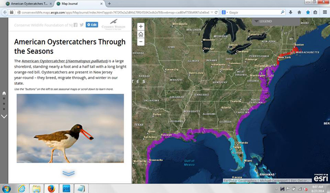
Conserve Wildlife Foundation (CWF), today released a new interactive “Wildlife Story Map” in support of this Saturday’s first annual World Shorebirds Day! The Story Map can be viewed here!

A Story Map is a web-based interactive GIS map embedded with multimedia content, such as text, photographs, and video. CWF, working with GIS software developer ESRI and with financial assistance provided by a grant from the New Jersey Division of Fish & Wildlife, plans to make this Story Map the first of many, helping engage the public about New Jersey’s rare wildlife in a dynamic and interactive way.
“American Oystercatchers Through the Seasons” tells the story about a species of migratory bird, the American Oystercatcher, which spends the summer breeding season along the New Jersey coast, but is present year-round along the southern New Jersey coast. Our state represents the northern limit of the species’ winter range. While some New Jersey birds migrate during the winter to Florida, those that breed in New England during the summer may end up spending their winter here in New Jersey.
This Story Map also provides stories about individual banded birds, which have been tracked on journeys between New Jersey and southern states such as Florida, as well as between New Jersey and more northern states, such as Massachusetts.
Make a donation today to support additional Story Maps!
How to Use the Story Map:
On the left side of the Story Map page are several “buttons” which will allow you to flip through the different seasons in an oystercatcher’s life: Breeding, Migration, and Wintering. Each page provides information and photos and a map specific to that portion of the bird’s life cycle. By clicking on an individual point within the map, a box containing more specific information, and a photo in some cases, will pop-up. The map also provides the ability to zoom-in and out in order to see areas of interest in more detail.
This Story Map is especially exciting since it helps celebrate the first annual World Shorebirds Day. This event seeks to “…raise global public awareness about the conservation of, and research about, shorebirds. About half of the world’s shorebird populations are in decline, and the rate of habitat loss is worse than ever before” (World Shorebirds Day 2014).
World Shorebirds Day hopes to accomplish the following:
- To raise public awareness about the need to protect shorebirds and their habitats throughout their life cycles;
- To raise public awareness about the need for ongoing shorebird research;
- To connect people with shorebirds through important shorebird sites around the world;
- To get shorebird enthusiasts to introduce shorebirds to more birdwatchers;
- To raise awareness about the need for increased funding for shorebird research, monitoring and conservation.
CWF’s shorebird leadership ranges from the American Oystercatcher celebrated in this Story Map, to the beach nesting birds along the Atlantic Coast, to the red knots and ruddy turnstones along the Delaware Bay.
Your support can help CWF develop additional Story Maps on other rare wildlife. Support our work on Story Maps on the American Oystercatcher and other important shorebirds in honor of World Shorebirds Day by supporting research, education, and public awareness efforts carried out by CWF:
We hope that this will be the first of many Story Maps that CWF will use in order to communicate the many fascinating stories that New Jersey’s wildlife have to tell.
Make a donation today to support shorebirds today!
Discover more from Conserve Wildlife Foundation of NJ
Subscribe to get the latest posts sent to your email.