Scarcity and Abundant – Shorebirds Near the Finish Line on the Delaware Bay

By Dr. Larry Niles, LJ Niles Associates, LLC

Our latest catch of red knots and ruddy turnstones two days ago (May 27) suggests 2017 to be one of the most challenging years for our 20 years of work on Delaware Bay. It challenged the birds for certain.

For example, as of two days ago (May 27), the average weights of red knots remain mired in the mid 160’s when it should be in the 180-gram range. This seems a minor difference but to red knots it means a flight through the cold and often inhospitable north country of Canada and dropping out of the sky never to be seen again or landing and never attempting to breed. We really don’t know for sure what happens to ill-prepared shorebirds, except they are less likely to be seen ever again. In 2017 most birds will be ill prepared.
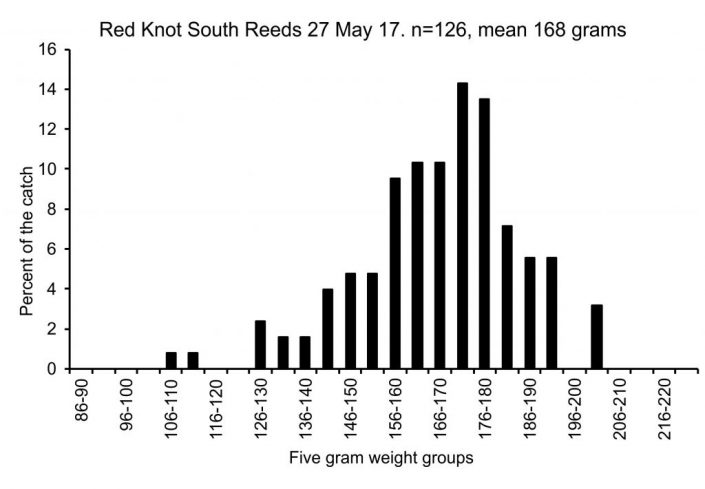
This histogram of the red knot catch made on May 27, 2017 shows the range of weights and the number of birds in each weight category. The average of 168 is far lower than the 180-gram threshold necessary for a successful flight to the Arctic.

This season also challenged our understanding because it lies so far outside the norm. To be sure the cause of this dramatic scarcity of horseshoe crab eggs springs from the cold weather this May. We started with a good crab spawn in the first week of May, when water temperatures rose somewhat faster than normal, a consequence no doubt of one of the warmest winters on record. Then cold and wet weather dogged the Bayshore until the day of this post. Today, temperatures will rise no higher than 70 degrees Fahrenheit and the prospects for warmer weather are unlikely for the rest of the week. The cold air temperatures forced down the bay temperature in the second week and although it has gradually improved it is still low by normal standards.

The Delaware Bay water temperature as measured by the bour off Lewis Delaware. The Bay warmed early until the second week of May when cold weather chilled the Bay.

All of this led to generally diminished horseshoe crab eggs especially on the beaches, the mainstay of most stopovers of the past. This year crabs mostly spawned in the creek mouth and outer creeks shoals, mostly spurred to spawn by tidal waters warmed by the movement in and out of the small estuarine systems. Water moves in with the tide and out again to the creek mouths twice a day warming the shoals.

The Importance of Tidal Creek Mouths and Shoals

A shoal at the mouth of BayCove creek and the crab spawn on Reed creek.

The creeks also accumulate sand leaving them loose and perfect for crab spawning. Even in good years, egg densities in the creeks top all beaches, no matter where they occur. The sands of the shoals loosen by the waves of the Bay and release more buried eggs than those buried in the beaches, making more available to the birds. The creek mouths on the Cape May peninsula from Green Creek to Moores Creek saved the birds from an even worse fate this year and the best were those that benefited from the restoration of Reeds, Cooks, Kimbles and Pierce Point Beaches. As it happens a major portion of the Bay’s knots stayed in this area throughout the entire month but flying widely in search of pockets of good spawning in other places. This year Norbury’s in the south and Goshen in the north stood out, and extended the core stopover area.

Horseshoe crabs breeding at Reeds South shoal.

Spawning Starts Again

Then in the last three days all changed. The new moon tides, reaching around 8 feet for four nights in a row, spurred spawning despite the relatively cool water. Today, May 29, the crabs shifted into high gear.

It takes a lot of crabs breeding to bring eggs to the surface on the beaches, there must be enough breeding for one crab to dig up the eggs of another. For the first time, this occurred in the last few night and we finally saw green eggs on the sand. A welcoming sight for the birds, who could barely stand still and gobble up the fat producing eggs. With most of these Arctic nesting shorebirds remaining in the Bay and apparently feeding right into the night, they still might reach the fat gain finish line and only lose a few days reaching the Arctic. The next few days will tell.
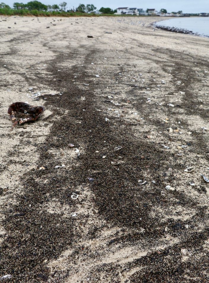
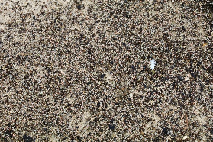
Horseshoe crab eggs litter the surface of North Reeds Beach.
A close up of the same beach. The immense number of eggs on the surface of the beach is in part due to the number of crabs spawning and the wave action of the Bay.
Shorebirds and Gulls feeding near dark in the intertidal flats and creek shoals of Reeds, Cooks, Kimbles and Pierce Point Beaches.

Can they though? A good question and just one of the many that have challenged our team’s knowledge of this well-known stopover. With literally centuries of combined experience (many of our team, including this author, are long in the tooth as the Brits would say) we still kept guessing what would happen next throughout the season. Would the birds suffer mighty declines as a consequence of the generally diminished spawn of horseshoe crabs?  Or will they build weight in time to get to the Arctic in good condition? This is usually the central question.

Why Are There Fewer Knots?

An equally intriguing question, however, is why have red knot numbers in Delaware Bay declined this year? We estimate shorebird numbers in two ways, direct observation by aerial and ground counts and a statistically derived estimate based on the resighting of birds flagged with unique IDs. Our aerial and ground counts tell us how one year compares to another because we have been doing shorebirds counts by airplane, boat and on the ground since 1981. This year the number fell dramatically.
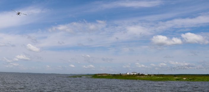
Guy Morrison, Christian Friis and Joe Smith survey shorebirds by airplane near Egg Island Point.

At the start of our project on Delaware Bay in 1986, we had nearly 100,000 knots on the Bay and nearly 1.5 million shorebirds of all species. The number of knots declined to around 15,000 in the mid-2000’s, then jumped to over 24,000 over the last four years. This year our best estimate is around 17,969, a 5,000-bird decline. Why did this happen?

One must always consider the possibility of a large group of birds dying. But this is not likely.

More likely, some portion of the knot flock came to the Bay, and on finding too few eggs or too much competition, moved on to better places. The ones moving on could have been the short distance migrants, those who spent their winter in Southeast US or the Caribbean. These birds travel a shorter distance and so have a longer time and lower energy needs than those that winter in South America. These long-distance migrants would have a very difficult time gaining weight on anything other than crab eggs (I explained this in a previous post). There are two reasons to believe the short distance birds moved on from the Bay this year.

The first is the discovery of birds banded in Delaware Bay this year and reported elsewhere. I reported on Mark Faherty’s Ebird report of a knot he saw in Cape Cod, that was flagged by the Delaware Bay Shorebird Team on May 16, 2017. The second line of evidence is the 1,300 birds seen by our team feeding on a 10-mile stretch of the Atlantic Coast marsh from Cape May to Stone Harbor. Play this out over the entire coast of New Jersey and other places with sand and marsh, like Cape Cod, and one could easily imagine 5,000 knots using other places.

About 200 knots feeding and roosting on the inter-tidal shoal of Hereford Inlet on the Atlantic coast.

But this reduction in population also suggests an explanation for the sudden rise in numbers found in 2013. Did the restoration of habitat on the Delaware Bay coast bring back knots that once used the Bay but stopped because of the lack of available eggs? In other words, did the increase in numbers seen in the Bay reflect a return of birds and not a population increase? This year’s loss may simply be a result of those returning birds, leaving once again.

Let’s hope so. At any rate, eggs are now available to all birds in the Bay and we should start seeing them leave for the Arctic. Let’s hope for that too.

Dr. Larry Niles has led efforts to protect red knots and horseshoe crabs for over 30 years.


LEARN MORE


In Dangerous Territory on the Delaware Bay

By Dr. Larry Niles, LJ Niles Associates, LLC

Four days ago, the shorebirds of Delaware Bay could look forward to a bright future. But in the last week their chances for survival and good production have diminished. In fact, they are as dismal as the cold drizzle pockmarking the murky water in front of our house on Reeds Beach.

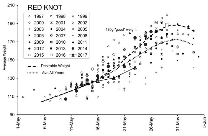
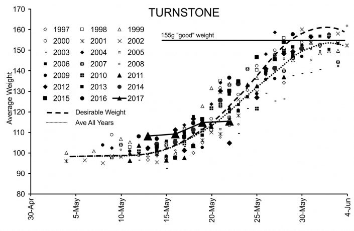
The following two graphs tell the story. We captured red knots on May 12 and 16 that showed a normal, although not spectacular progression. Then we made a catch of knots on the 19th and again today on the 23rd, and in total they gained only 2 grams of fat per day. With an average weight of 144 grams at this late date and only 7 days to go before they must leave for the Arctic, their future looks bleak. If current conditions hold, the knots will suffer their worst year in 14 years. Turnstones fared no better gaining less than a gram per day on average.

The graph plots all the average weights of all the catches of red knot our team has made since 1997. The average weight of our catch on May 23 suggests trouble is brewing for these birds.


The graph plots all the average weights of all the catches of ruddy turnstones our team has made since 1997. The average weight of our catch on May 22 suggest trouble for both species.

So why this dismal report? Several factors are at work that were covered in my last post. The water temperature of the bay has only just exceeded the threshold for horseshoe crabs to start breeding in earnest. But the nights are cold and the water temperature remains cold. Last night was the first good crab spawn since the birds arrived and it was lackluster. Although there is some spawning in the creek mouth shoals and the lower beaches near Norburys Landing and Villas, our most productive beaches remain nearly devoid of crabs and crab eggs.

The second problem is still a mystery. At this stage only about half of the red knots have found their way into the bay. Weather patterns in the southern US could have been blocking migration for the last 5 days because adverse winds, poor visibility and rain impedes birds progress and could stop northward movement. The conditions have finally let up, so it possible a new cohort of birds might arrive any day. If so they will face a true food fight with many birds already here and desperate for eggs.

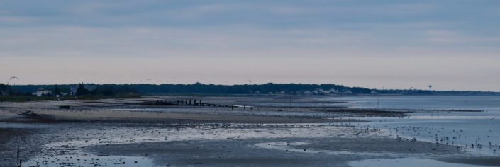
Laughing Gulls, Red Knots, Ruddy Turnstones, Sanderlings and Semipalmated Sandpipers struggle to find horseshoe crab eggs on the shoals of South Reeds Creek. Eggs are scarce because cool water temperatures prevent crab spawning.

However, it may not be the adverse weather but choice that is keeping the population down. Today we learned of a red knot banded on May 16 this year by our counterparts in Delaware that was resighted in Cape Cod by Mark Faherty, the senior scientist for Massachusetts Audubon in Cape Cod. In other words, red knots and other shorebirds are coming to the bay finding too little food or too much competition for the food now available and choose to move on. This is very possible for the short distance migrants because they arrive earlier and have less weight to gain before leaving for the Arctic. Knots wintering in Tierra del Fuego, arrive later and in much worse condition, often times lose muscle mass to get here. They cannot recover that loss and still gain an extra 80 grams on their normal diet of mussels and clams.

We tried to test this second possibility today (May 23) after our red knot catch this morning. Humphrey Sitters, Amanda Dey and I surveyed the intertidal mud flats of the Atlantic Coast from Cape May to Stone Harbor looking closely at the mussel beds. We know that every year red knots, especially short distance birds, use mussels and to some extent clams, rather than come to the bay and feast on horseshoe crab eggs – simply because they can. We found 1700 knots, so it possible even more are spread out further up and down the coast.

In the end, it may turn out to be both explanations. The short distance knots are using the Atlantic Coast and the long-distance birds have yet to arrive. One should remember that the knot is federally listed in both Canada and the US primarily because of the dramatic declines in the long-distance winters. There is still a small window for a successful outcome. The next few days will tell the full story.

Dr. Larry Niles has led efforts to protect red knots and horseshoe crabs for over 30 years.


LEARN MORE


Shorebird Expedition Brazil: Going to the heart of the mangroves

Hundreds of red knots found to cap long day’s journey

By Larry Niles, LJ Niles Associates LLC

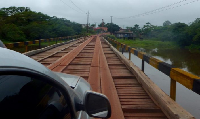
It took us long into the night to reach our next port.  We went from the relatively populated area of Braganza to the dark heart of this coastal region of Viseu. In three trucks, we caravanned through a maze of remnant tropical rainforests, cattle pastures, and impenetrable second-growth woodlands. Along the rain-slicked, red clay road, small and desperate looking towns popped out of nowhere always looking like the past was a better day. The road cut through countless mangrove forests that define this region.  We reached Viseu too late to do anything but find a place to stay the night.

A bridge across the many rivers from Braganca to Visiu, Brazil. Photo by Christophe Buiden.

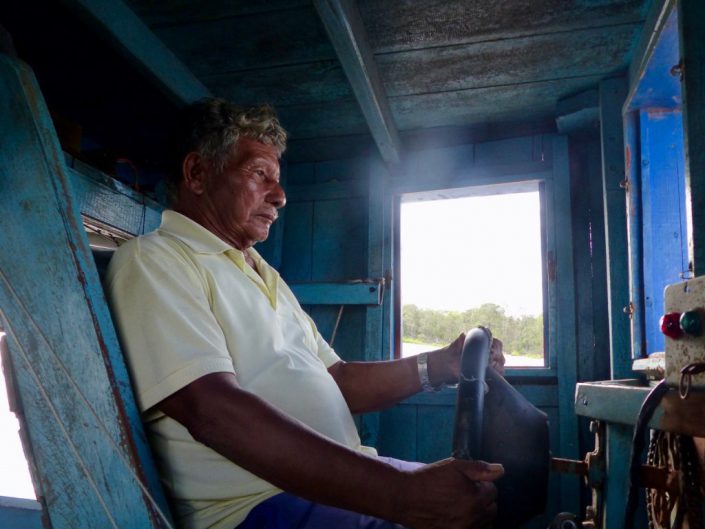
By noon the next day, we boarded a Lancha boat named Garota Viseu (Viseu Girl). Local shipwrights craft these two-decker boats of about 50 feet in length, primarily to carry cargo and people from port to port.  Today it will carry us into one of the most remote estuaries in the 250-mile coastline of this enormous mangrove and beach landscape.  Our captain, 78-year-old Benedicto, with one crew navigated the coffee- colored Gurupi, a long river that cuts deep into the tropical coastline.

A nearly completed boat in a ship yard in Viseu.

Bene took his craft down the Gurupi within sight of the wind-tossed Atlantic Ocean.  The trade winds blow constantly here, almost always at near gale levels.  But then he turned into a small channel directly into the steamy mangrove forest.  At first the path was wide, lined with a dense tangle of mangrove on either side.  Whimbrels, scarlet ibis, semi-palmated sandpipers clung to tangles of roots as the high tide flooded the soft mud.

Captain Benedicto piloting his Lacho boat, the Garota Viseu.

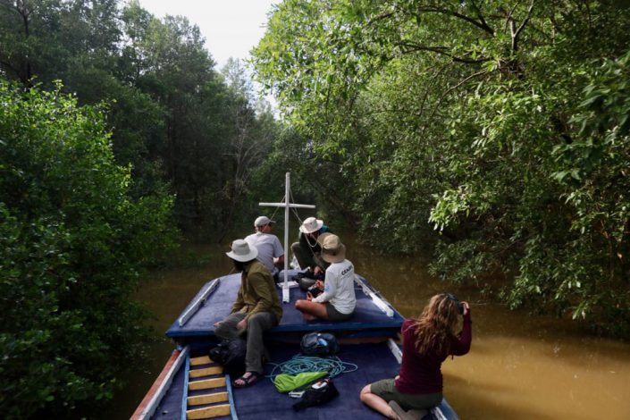
Then he took the boat in a channel so narrow, the crew had to duck the whipsaw of mangrove branches.  We slowly snaked our way through a tunnel of green until we reached another wide channel.  Within a few minutes, we entered another narrow channel ultimately reaching the next bay.  Here we felt the full force of the stiff winds and deep rolling swell of the Atlantic.  An hour later we weighed anchor at the small community of Apiu Salvadore.

The Garota Viseu weaves its way through the narrow mangrove passage. Stephanie Feigin, Danille Paluto, Christophe Buiden and Yann Rochepault watch from the top deck of the boat.


Few people from the outside world come to this community of about 50 ramshackle huts and cabins and about 150 people. As the boat neared the shore with most of the team standing on the roof of the boat, scattered groups of the town’s people stood on the sandy bluffs overlooking the harbor as though we just landed from space.  Ultimately, we found them welcoming but wary.  Little good comes from the outside to these communities.


Over the next two days, we plied our craft of field biology. We needed to find small boats to take teams to the various shorebird habitats previously determined on our maps. Local craftsmen build these boats. Running about 20 feet in length, they use 10 to 20 horse power engines meant for something like a lawn tractor. Instead of driving a blade, the craftsmen power a long shaft that ends in a 8-inch propeller. The skipper can lift the engine and propeller according to the water’s depth. They suited our needs perfectly.


We fielded five teams in three in boats while Mandy, David Santos, Carmem and I surveyed Lombo Branco Island, about two miles from the Apiu Salvador. The sea shapes this island into a crescent, the inside protected from the restless waves.  Nestled within, one could see in miniature, the whole ecological system that creates resources for shorebirds.


At the heart of the island grows a small and stunted mangrove forest and an apicum, or wetland that only floods during lunar tides or spring tides. These are the highest of the monthly cycle of tides but only occur on the full and new moon. Every day the tide moves in and out of this small system. Twice a month the tide floods the apicum for several days at a time.

We arrived on the day of a waxing moon, near full. The very high-high tides reached well within the small drainage flooding habitats that have not been flooded in a few weeks. Shorebirds carpeted the wet mud, searching for all the invertebrate life that flourishes in this habitat. But the productivity only starts there. Here the tidal flow is gentle because the island shields it from the wind tossed Atlantic from all sides except the leeward quarter of the island. This gentle tidal flow flushes sediments from the mangrove swamp, the nutrients of the apicum and the normal productivity of a sediment-rich sandy substrate, forming the base layer of a productive food chain that nurtures small clams and other invertebrate – all prey for shorebirds.


We found whimbrels, semi-palmated sandpipers, ruddy turnstones, short-billed dowitchers, black belly plovers, willets, semi-palmated plovers, sanderlings and collared plovers.  In the lower reaches, we found 337 knots, a glorious find that will help our mapping model enormously.

Red knots, sanderlings, short billed dowitchers and other shorebird forage in the inter-tidal estuary of Morro Branco.

The following day we surveyed a second island, Coroa Criminosa. Why the sinister name we cannot say, but it supported a very similar esturary giving us another successful day. When the tide went out the small island of about 6 kilometers grew to over 20 kilometers. Intertidal sand flats spread out of sight in nearly all directions.


We left the island that night and arrived in Viseu just before dark. Once again we suffered the sway of the Atlantic. After weaving our way back through the mangrove and up the Gurupi River, we landed too late to go on.  We were thankful for the modest rooms with showers, a good meal and beer!


https://youtu.be/zLW4iRr_EI4


Dr. Larry Niles has led efforts to protect red knots and horseshoe crabs for over 30 years.


Shorebird Expedition Brazil: Conducting a scientific investigation in a tropical wilderness

By Larry Niles, LJ Niles Associates LLC

It’s hard to imagine the difficulties of people living here at Latitude 37 Degrees North when arriving at the equator in northern Brazil. It challenges even the hardiest of biologists. However, after three days our team has not only acclimated but we accomplished surveys in two separate estuaries.


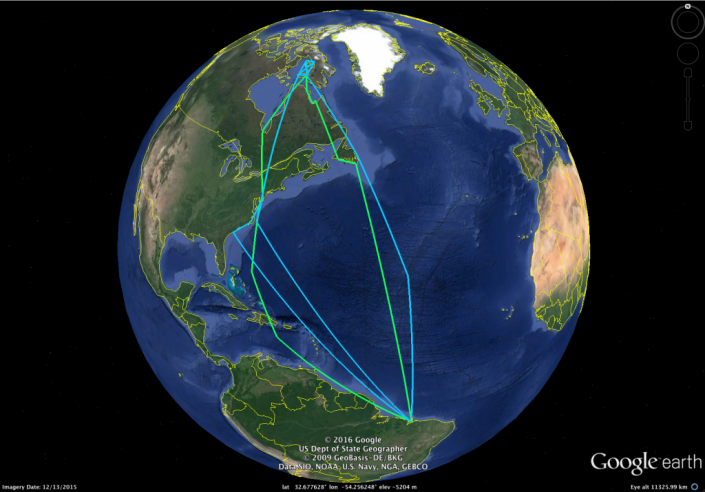
Ruddy turnstone multiyear flight recorded by a geolocator caught in Maranhoa, Brazil.


Low tide was cut short on our first day in the field, while high tide persisted longer than we expected which challenged our surveying since it must take place when birds forage. Shorebirds typically forage until 1 to 2 hours before high tide and start again 1 to 2 hours after high tide, usually resting and digesting the food consumed at the lower tides. Because we intend to understand the foraging habitats of shorebirds in the wintering area, we must focus on the lower tides. This is always difficult due to logistical issues such as renting boats, equipment failures, and long distance from the ports present an array of complications. Still, we were able to go out in the field and collect some data.


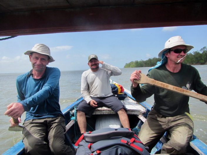
The next day we did marginally better, each team member faced different problems. Our boat engine failed and we had to paddle back to port, another boat took so long to get to the shoal we intended to survey that it had already been covered by the tide.  But this is the nature of field work anywhere.


Yann and Christophe paddle our boat back to port after the engine failed.


No matter the complication, it is important to stick to our rigid protocols.  Our goal is to determine the best places for shorebirds in this area. We must work with the shorebird’s behavior because each tidal stage creates different value.  In a wild place such as this, they will choose to roost as close to the foraging areas as possible. In fact most will just roost then feed as the tide recedes then feed as the tide rises and then roost again.  So locating the feeding areas will usually indicate the roosting areas.


But things can go awry. In human dominate habitats like New Jersey, birds find it hard to roost near foraging areas. Most often the high tide forces them into people jogging, dog walking or enjoying flushing shorebirds.  So the shorebirds must leave, unnecessarily burning valuable fuel and suffering greater danger from avian predators.


The night-time roost creates the real threat here in Brazil and everywhere. At night many dangers lurk.  Ground predators, such as owls, feral cats, raccoons, and even people will take advantage of any unwary or sickened bird.  It is worse when birds are forced to use areas that are less secure than others. This can happen naturally at spring tides, for example, when the very highest high tides force them closer to the dangers lurking in the dunes or mangrove forests.  In places like Hereford, New Jersey, people often force birds to use more dangerous areas.


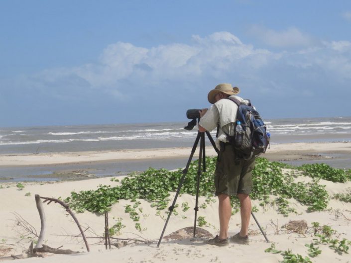
Larry Niles surveying.


So our goal here is to map all the areas of importance – foraging, day-time roosts and night-time roosts.  But we hope to do it with remote sensing; satellite maps that are trained by a mathematical model, that are, in turn, trained by our field data.  We count birds, photograph the surrounding habitats, precisely locate the sites, and even look at the substrate.  Is it mud, sand, muddy sand, sandy mud and so on?


Doing this in New Jersey is difficult.  Doing it in the northern coast of Brazil presents untold challenges.  One cannot easily access the coast here.  We have to rent boats to take us out to the birds, conduct surveys then get back before dark.  Sometimes we go out for days and stay in remote fishing villages, sometimes with only a floor to sleep and no facilities or power. Imagine unrelenting heat, mosquitoes, persistent blowing sand, copious sweat, and trying to conduct a scientific investigation. That would be demanding in any environment.


So this is the challenge of our crew – and they do it aplomb!  Last year one of the boats sank in 55 feet of water 8 miles out to sea. We all made it to land safely but we lost much of our equipment. The day after was grim, wondering if we should we go on or go home?  Without hesitation, not only did the crew go on to complete the survey but we ended up capturing twenty-two geolocators from ruddy turnstones tagged two years earlier. A good crew is hard to put together and stay productive in these conditions. A good spirit is the most important thing.


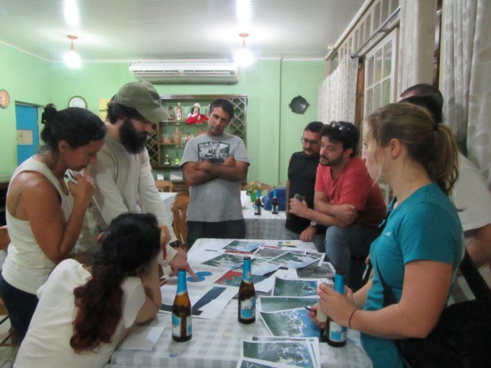
Our team chooses areas for the next day’s surveys. Beer is essential!


So we completed two days of surveys at the western end of our 150 miles long study area. Today we prepare for three days out to a remote area, accessible by boat only.  As I write, the team prepares for food, water and all the necessities of spending three days with minimum comfort.  We hope to camp in a fishing village, maybe a house, but we won’t know until we get there. We must prepare for all possibilities.


Our understanding of the inner workings of the Brazilian Extractavista reserve system grows every day. This system I believe holds great hope for us in the United States because it serves both the wildlife and fish and the people living in the landscape.  Pretend, for example, on Delaware Bay, the rural towns and the residents get first crack at the sustainable management of resources, not the companies exploiting them without regard to the future, as it is now. Instead of few people earning a good living off Delaware Bay resources, many would. Rural American would be transformed. This is what ICMBio hopes to achieve in this much poorer area.


Two members of our team are managers of the seven reserves in Para, our study site. They told us, for example, ICMBio (Chico Mendes institute), the federal agency in charge of the extractive reserves, pays a subsidy for local fishermen in exchange for helping manage the fishery resources. But the subsidy is limited to existing residents, not people within new reserves because of the new conservative government. One can see right away the challenges of two people managing seven reserves covering a coastline the size of New Jersey. Budget cuts have taken away all equipment funds. They must even clean their own offices as most nonessential staff has been cut under the new conservative government, a government accused of unfairly deposing the most popular liberal party.


This should resonate in the United States because it could be coming soon to a wildlife reserve near you.


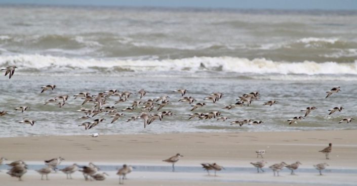
Wintering knots in roost.

Dr. Larry Niles has led efforts to protect red knots and horseshoe crabs for over 30 years.