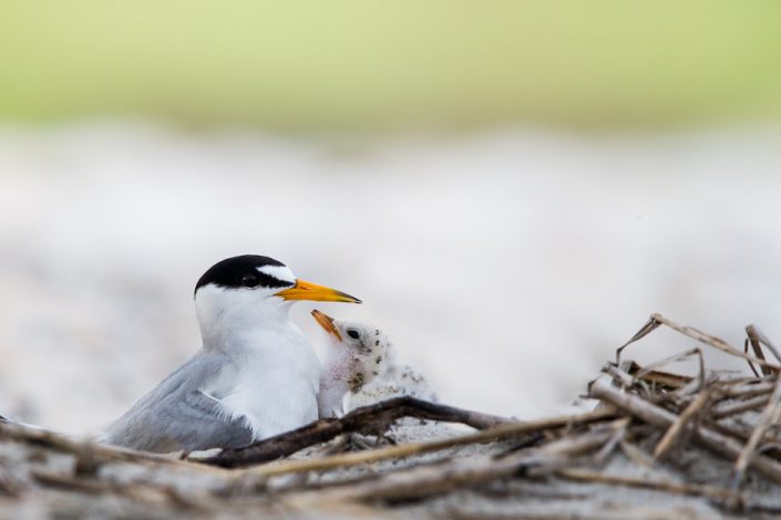
Beachnester Buzz: Least Terns Chicks Starting to Hatch

NEW, WEEKLY UPDATES FROM NEW JERSEY’S BEACH NESTING BIRD PROJECT TEAM

by Todd Pover, Beach Nesting Bird Project Manager

Least tern photo by Northside Jim.

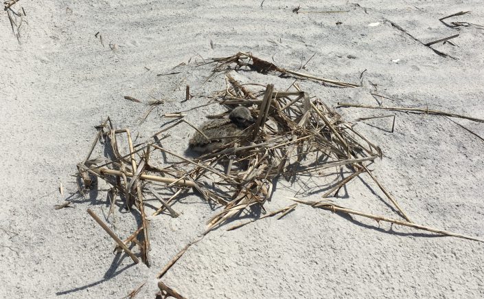
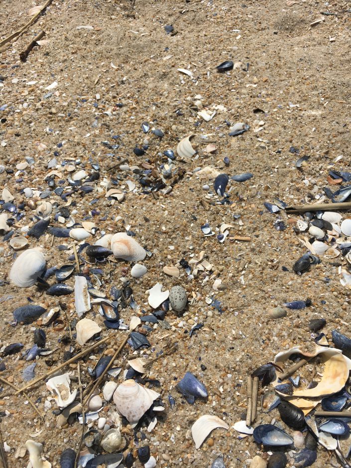
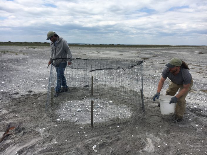
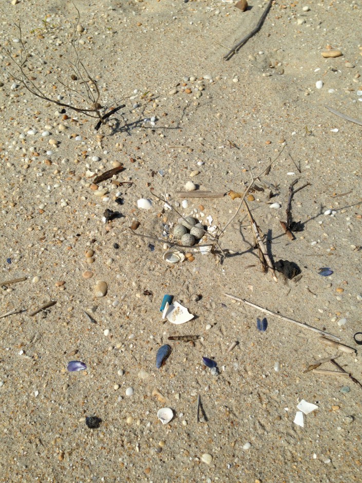
The beach nesting bird field staff is firing on all cylinders now, frantically trying to keep up with nesting activity. In some regions of the New Jersey coast, piping plovers and American oystercatchers are still laying eggs, while at other sites there are chicks on the beach, even one site (Barnegat Light) where the chicks are already approaching their “fledgling” stage when they will be able to fly.

CWF Field Technician Jesse Amesbury busy conducting annual piping plover census at Edwin B. Forsythe NWR.

Most of the least tern and black skimmer colonies are now established, with least terns starting to hatch chicks and black skimmers just laying eggs. Counting the colonies is one of the most challenging parts of the job, imagine trying to count 1,000-1,500 birds at a time in some instances!

After helping with the winter segment of the International Piping Plover Census in the Bahamas, CWF switched gears this week to help conduct the breeding portion in New Jersey.

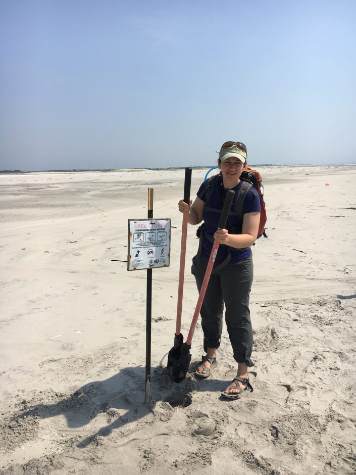
All the normal beachnester tasks are keeping us busy, but the main focus this past week was the annual piping plover “window” census, where field biologists all along the Atlantic coast count the number of birds present between June 1-9, so we can get a range-wide breeding population estimate. As for New Jersey, it looks like our population will go up, at least slightly, for the second year in a row. Although this is still a very preliminary estimate, it looks like we have weathered the statewide low in breeding pairs we recorded in 2014, thanks to good productivity the past two years.

Of special note is a spike in Monmouth County (outside Sandy Hook), where we have gone from 2 pairs the past several years to 12 pairs this year. Although a smaller bump, we also went from 1 pair to 4 pairs within Barnegat Inlet, an area we have long hoped for more pairs. It takes a tremendous effort to realize even small gains in our piping plover recovery effort, so we are especially excited about this news!

Our work is never done...CWF Wildlife Biologist Emily Heiser posting a new nesting area for endangered least terns.
Our work is never done…CWF Wildlife Biologist Emily Heiser posting a new nesting area for endangered least terns.

Learn More:


Todd Pover is the Beach Nesting Bird Project Manager for Conserve Wildlife Foundation of New Jersey.

Beachnester Buzz: First American Oystercatcher Chicks of the Season Hatch

New, weekly updates from New Jersey’s beach nesting bird project team

by Todd Pover, Beach Nesting Bird Project Manager

American Oystercatcher Chick
American oystercatcher Chick

It has been a busy week on the beach nesting bird project! We had our first least tern nests of the season, as the brief spell of warmer weather (finally) made for a burst of breeding activity. The first American oystercatcher nests hatched, so we have chicks on the beach now, as well.

Least Tern Nest
Least Tern Nest

And there was a big spike in new piping plover nests all along the coast, so we were busy erecting “predator exclosures” to protect the eggs from predators, such as crows, cats, gulls, and foxes. While they are not effective or viable to use on every nest, these wire cage structures are one of our best management techniques to increase hatch success by deterring predators.

Piping Plover Exclosure


This week we will be even busier, as we make a mad scramble to protect the nests and colonies before the crowds of beachgoers arrive for the Memorial Day weekend!


Learn More:


Todd Pover is the Beach Nesting Bird Project Manager for Conserve Wildlife Foundation of New Jersey.

Researching Beach Nesting Birds at Edwin B. Forsythe National Wildlife Refuge

Conserve Wildlife Foundation Partners with National Wildlife Refuge to Collect Data on Beach Nesting Birds

Posted by: Lindsay McNamara, Communications Manager


Piping Plover Nest
Piping Plover Nest

Did you know barrier island beach makes up approximately 2% of the Edwin B. Forsythe National Wildlife Refuge? This area is the most productive for beach nesting birds. The federally threatened piping plover and other species such as least tern, black skimmer, and a species of special concern, the American oystercatcher, nest on Holgate Beach. The refuge closes the Holgate unit from April 1st to September 1st every year to provide undisturbed nesting habitat for these important species.


Not only is it important to protect nesting habitat for the birds, but it is also important to provide education opportunities to the public. Each summer, the refuge relies on volunteers during the summer months to talk to the public about the beach closure and bird management, and answer any general questions about Forsythe Refuge.


This year, Conserve Wildlife Foundation of New Jersey partnered with the refuge to assist in the collection of nesting data. “In the past, refuge staff has done all the beach nesting bird monitoring,” said Refuge Manager Virginia Rettig. “This year we are very excited to be working with our partners to monitor the population status of these birds. The work they are doing, combined with the data they collect, will improve our understanding of beach nesting birds on Forsythe Refuge.”


CWF Field Technician Jesse Amesbury tracking piping plovers at Holgate with his scope.

“Holgate provides highly suitable undisturbed natural habitat for at-risk beach nesting birds, especially piping plover – a rarity along the otherwise highly developed and recreated New Jersey Coast,” said Todd Pover, CWF Beach Nesting Bird Project Manager. “Maximizing productivity at this site is a high priority for regional and range-wide recovery efforts.”


Edwin B. Forsythe National Wildlife Refuge protects more than 47,000 acres of sensitive wetlands, marshes, and coastal habitats along the New Jersey shore. It is one of the most important habitats for migrating waterfowl and shorebirds east of the Mississippi River.

Learn more:

Conserve Wildlife Foundation’s Beach Nesting Bird Project
Edwin B. Forsythe National Wildlife Refuge


Lindsay McNamara is the Communications Manager for Conserve Wildlife Foundation of New Jersey.

Conserve Wildlife Foundation of New Jersey “2014 Annual Report” Released

CWF Releases its First Annual Report Ever Using a Story Map Format: “2014 Annual Report

By David Wheeler, Executive Director

Technology has proven to be vital to Conserve Wildlife Foundation’s work protecting rare wildlife species over the years. Our biologists depend greatly on modern technologies to band, track, and share online the journeys of wildlife. Our webcams broadcast the most intimate behaviors of nesting birds and bats across the web. And we seek out ever-evolving communications technologies to spread the word about the inspiring stories of wildlife, from social media and infographs to e-books and Story Maps. These technologies offer newfound abilities to share complex data on multiple levels, while still incorporating the awe-inspiring photography and videos that bring wildlife’s stories to life.

Conserve Wildlife Foundation of New Jersey is excited to offer our 2014 Annual Report in a unique format that utilizes one of those technologies – Story Maps. In the past year, we have explored the wonders of American oystercatchers with our first Story Map – and now the annual report allows all of our projects to be highlighted in this interactive format.

A screen capture of one of the pages of the CWF 2014 Annual Report Story Map.

Visit the multiple pages within this Story Map to learn about Conserve Wildlife Foundation’s many projects and partnerships in 2014, and the imperiled wildlife species in need of our help. Find examples of the innovative and dedicated leadership of our biologists and volunteers. And take an online journey across the state to learn how our projects made a difference in all corners of New Jersey in 2014 – a great year for wildlife in the Garden State!


Celebrate GIS Day with Conserve Wildlife Foundation of New Jersey

By: Lindsay McNamara, Communications Coordinator

Data nerds rejoice! Today, Wednesday, November 19 is GIS Day. Geographic information systems (GIS) technology helps our wildlife biologists protect rare species throughout New Jersey. GIS technology is used to create our species range maps and other important tools that show where wildlife occur and what habitat they need to exist.

Conserve Wildlife Foundation is a key player in updating the NJ Endangered and Nongame Species Program’s (ENSP) database of rare wildlife species. The database called “Biotics” is a GIS and Oracle-based system developed by NatureServe, the leading source of information on the precise locations and conditions of rare and threatened species and ecological communities in the Western Hemisphere.

Although CWF and ENSP biologists submit a majority of the data on Biotics, we rely on the help of citizen scientists to fully understand the wildlife picture in New Jersey. Do you want to help biologists monitor certain areas of the state and locate the presence of species of concern? Visit our website to learn how you can get involved.

In addition to the Biotics database, GIS was used to create range maps for all 190 species featured on our online field guide! Check it out.

Have you seen our American Oystercatcher Story Map? GIS was used to create that tool as well! A Story Map is a web-based interactive GIS map embedded with all kinds of content, like text, photographs, and video.

storymap
“American Oystercatchers Through the Seasons”
 tells the story about a species of migratory bird, the American Oystercatcher, which spends the summer breeding season along the New Jersey coast, and is present year-round along the southern New Jersey coast. Learn more about our Story Map.

This GIS Day, take a look at all of the maps around you and consider supporting additional Conserve Wildlife Foundation Story Maps!


Lindsay McNamara is the Communications Coordinator for Conserve Wildlife Foundation of New Jersey.

Happy World Shorebirds Day!

American Oystercatcher
American Oystercatcher. © Jim Gilbert

On behalf of our friends – the piping plovers, red knots, American oystercatchers, least terns, ruddy turnstones, black skimmers, and many others – Conserve Wildlife Foundation wishes you a happy World Shorebirds Day.

  • For your viewing pleasure, check out our brand new Oystercatcher Story Map.
  • To learn more about our beach nesting birds work, click here.
  • You can click here to learn about our migrating shorebirds work.
  • And if you haven’t seen the Delaware Bay beach restoration video yet, enjoy it here!

Finally, you can help support our shorebirds work with a donation, or through volunteering on one of our shorebird projects.

Click here to make a donation to our shorebird work here!


One other fun way to cozy up to a bird this fall is to visit Unreal Birds, and consider making a purchase of those adorable birds. A portion of every purchase benefits CWF!

Story Map Brings Oystercatchers to Life Online

CWF Celebrates World Shorebirds Day With Release of Our First Story Map: “American Oystercatchers Through the Seasons”

By Michael Davenport, GIS Program Manager

Conserve Wildlife Foundation (CWF), today released a new interactive “Wildlife Story Map” in support of this Saturday’s first annual World Shorebirds Day! The Story Map can be viewed here!

ScreenCapture

A Story Map is a web-based interactive GIS map embedded with multimedia content, such as text, photographs, and video. CWF, working with GIS software developer ESRI and with financial assistance provided by a grant from the New Jersey Division of Fish & Wildlife, plans to make this Story Map the first of many, helping engage the public about New Jersey’s rare wildlife in a dynamic and interactive way.

 “American Oystercatchers Through the Seasons” tells the story about a species of migratory bird, the American Oystercatcher, which spends the summer breeding season along the New Jersey coast, but is present year-round along the southern New Jersey coast. Our state represents the northern limit of the species’ winter range. While some New Jersey birds migrate during the winter to Florida, those that breed in New England during the summer may end up spending their winter here in New Jersey.

This Story Map also provides stories about individual banded birds, which have been tracked on journeys between New Jersey and southern states such as Florida, as well as between New Jersey and more northern states, such as Massachusetts.

Make a donation today to support additional Story Maps!


How to Use the Story Map:

On the left side of the Story Map page are several “buttons” which will allow you to flip through the different seasons in an oystercatcher’s life: Breeding, Migration, and Wintering.  Each page provides information and photos and a map specific to that portion of the bird’s life cycle. By clicking on an individual point within the map, a box containing more specific information, and a photo in some cases, will pop-up. The map also provides the ability to zoom-in and out in order to see areas of interest in more detail.

This Story Map is especially exciting since it helps celebrate the first annual World Shorebirds Day. This event seeks to “…raise global public awareness about the conservation of, and research about, shorebirds. About half of the world’s shorebird populations are in decline, and the rate of habitat loss is worse than ever before” (World Shorebirds Day 2014).

World Shorebirds Day hopes to accomplish the following:

  • To raise public awareness about the need to protect shorebirds and their habitats throughout their life cycles;
  • To raise public awareness about the need for ongoing shorebird research;
  • To connect people with shorebirds through important shorebird sites around the world;
  • To get shorebird enthusiasts to introduce shorebirds to more birdwatchers;
  • To raise awareness about the need for increased funding for shorebird research, monitoring and conservation.

CWF’s shorebird leadership ranges from the American Oystercatcher celebrated in this Story Map, to the beach nesting birds along the Atlantic Coast, to the red knots and ruddy turnstones along the Delaware Bay.

Your support can help CWF develop additional Story Maps on other rare wildlife. Support our work on Story Maps on the American Oystercatcher and other important shorebirds in honor of World Shorebirds Day by supporting research, education, and public awareness efforts carried out by CWF:

We hope that this will be the first of many Story Maps that CWF will use in order to communicate the many fascinating stories that New Jersey’s wildlife have to tell.

Make a donation today to support shorebirds today!


Oystercatcher Project in Flight

Surveying American Oystercatchers from the Sky

By Stephanie Egger, Wildlife Biologist

Stephanie Egger of CWFNJ, before take off.
Stephanie Egger of CWFNJ before take off.

If you happened to be taking a stroll on a chilly February afternoon on the beaches of New Jersey and you saw a blue and white Cessna in the sky flying in a not-so-straight pattern, well that was me in the back of the teeny 4-seater plane.  Last Tuesday I helped complete the New Jersey segment of the American oystercatcher winter survey, which is being directed by Shiloh Schulte from the Manomet Center for Conservation Sciences, in partnership with the American Oystercatcher Working Group. Other staff from the Conserve Wildlife Foundation of New Jersey and the State’s Endangered and Nongame Species Program were on the beach (or in a boat) “ground-truthing” the survey in order to verify the data that were collected during the flight.

Flight Path
Flight path during one portion of the New Jersey survey for American oystercatchers.

After swallowing a motion sickness pill as a precautionary measure (thanks Shiloh!) our four hour flight took off early afternoon from the Cape May County Airport, starting with a survey of Cape May Inlet.  We continued our flight north, surveying Hereford, Townsend’s, Corson’s, Great Egg Harbor, Absecon, Brigantine, Little Egg, Barnegat, and Manasquan Inlets and finally Sandy Hook Gateway National Recreation Area.  We saw flocks of wintering oystercatchers, from a handful to up to 140 birds, using sand and marsh habitats.  It was quite the first-time experience for me. Surveying from the air is NOT the easiest, but especially if a flock is seen at the last second and the plane has to bank hard. I admit I even glanced around for a sick bag a few times, but stayed strong! I don’t get seasick or airsick, but flying in a Cessna and doing numerous turns and banking was a whole new feeling.  There were many times all I could see from the backseat was water with no horizon to focus on, all while attempting to take good photographs of the flocks for the count. Try doing that when you are sideways!  In the end I managed to do really well at both, taking photos of the flocks and not getting sick during my aerial survey. Go me! Continue reading “Oystercatcher Project in Flight”

MIGRANTS AND MANATEES

FOLLOWING OUR FLYWAY “FRIENDS” TO FLORIDA

By Todd Pover, Beach Nesting Bird Project Manager

When cold weather settles in, as it recently did, our thoughts often turn to the south and warmer temperatures. Many of our long-distance migrant bird species are one step ahead of us, having already flown south for the winter.  Stephanie Egger and I, CWFNJ’s Beach Nesting Bird Project team, recently had the chance to join some of them in Florida.

The purpose of our trip was to attend the American Oystercatcher Working Group annual meeting to learn what our colleagues all along the Atlantic and Gulf coasts are doing to protect and study oystercatchers, and to share what we are doing in New Jersey as well. This year’s meeting was held in Cedar Key, Florida, a small town about two hours north of Tampa that is a very special place for oystercatchers. It is not unusual to find flocks of 500-1000 oystercatchers roosting on oyster shell rakes just offshore from this quiet gulf town, making it one of the most important wintering sites for this species in the U.S.

“New Jersey” oystercatchers are typically found in the Cedar Key flocks – birds that bred in New Jersey and were marked with orange color bands that have unique two-digit codes.  These bands and similar bands or flags used by other states, help researchers track movements and learn about the long-term survival of this species.  Continue reading “MIGRANTS AND MANATEES”

HURRICANE SANDY STORM REPORT

Assessing the damage to coastal wildlife and their habitat

By Stephanie Egger, Wildlife Biologist

CWFNJ Wildlife Biologist, Stephanie Egger, surveying American Oystercatchers post Hurricane Sandy.

As we all know Hurricane Sandy caused severe damage and devastation to New Jersey residents, homes, and their businesses, but we must not forget that wildlife can also suffer from the impacts of a hurricane.  CWFNJ’s Beach Nesting Bird Project Manager, Todd Pover, Alfred Breed, CWFNJ Field Technician, and myself, conducted wildlife/habitat assessments on beaches from Brigantine to Cape May after the storm.  Our nesting sites further north in Ocean and Monmouth Counties were still not accessible at that time to evaluate.  We assessed nesting habitat for beach nesting bird species, especially Piping Plover as well beach/inlet habitat used by migratory shorebirds, particularly American Oystercatchers.

A view of the severe erosion at Strathmere Natural Area, Cape May County, NJ.

As expected, many of our nesting sites and sites that are also used by migratory shorebirds for roosting were hit hard by Hurricane Sandy, losing a great deal of sand and suitable habitat.  However, in some locations such as Stone Harbor Point and North Brigantine Natural Area, the storm scoured out areas with too much vegetation which is good for beach nesters as they prefer sparsely vegetated areas. Sand was also pushed back into the dunes to create blowouts and overwash areas that may serve as additional habitat.  Many of the areas seem to be very low lying now from the loss of sand and might be more flood prone which could impact the beach nesters in the spring.

We also observed migratory songbirds, golden-crowned kinglets, which were taking shelter and flittering through the back dune/bayberry habitat right after the storm.  This was a good reminder of the value of New Jersey coastal habitat for songbirds as they migrate down the coast.

American Oystercatchers roosting with juvenile Black Skimmers at Strathmere Natural Area, Cape May County, NJ

As part of our assessment, we conducted American Oystercatcher surveys as a significant number use New Jersey beaches for roosting during the fall and winter.  Luckily, approximately 900-1,000 American Oystercatchers were still using our southern coastal inlets after Sandy, about the same number of birds observed the week before the storm.  Thanks to funding from the National Fish and Wildlife Foundation we were already conducting fall surveys for American Oystercatchers and in the position to compare their numbers before and after the storm.

Only time will tell if the habitat will build back up enough in time for the spring as the birds begin to arrive for the nesting season or if it will have lasting impacts on migratory bird species. We hope to conduct further assessments to gain a better understanding of the short- and long-term impacts to wildlife from Hurricane Sandy and how that may affect conservation and recovery effort for these species moving forward.


For CWFNJ’s videos of wildlife and habitat assessments click on the links below:

Wildlife Assessment Post Hurricane Sandy at North Brigantine Natural Area, NJ

Wildlife Assessment Post Hurricane Sandy at Stone Harbor Point, NJ

Wildlife Assessment Post Hurricane Sandy at Strathmere Natural Area, NJ