Shorebird Expedition Brazil: Going to the heart of the mangroves

Hundreds of red knots found to cap long day’s journey

By Larry Niles, LJ Niles Associates LLC

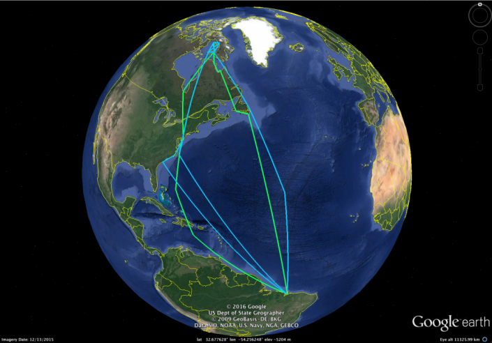
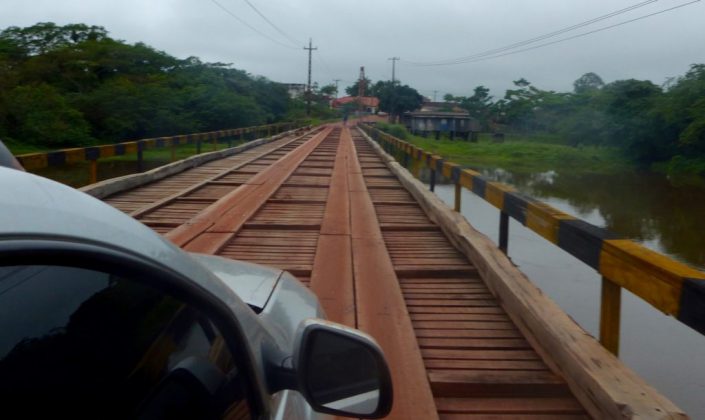
It took us long into the night to reach our next port.  We went from the relatively populated area of Braganza to the dark heart of this coastal region of Viseu. In three trucks, we caravanned through a maze of remnant tropical rainforests, cattle pastures, and impenetrable second-growth woodlands. Along the rain-slicked, red clay road, small and desperate looking towns popped out of nowhere always looking like the past was a better day. The road cut through countless mangrove forests that define this region.  We reached Viseu too late to do anything but find a place to stay the night.

A bridge across the many rivers from Braganca to Visiu, Brazil. Photo by Christophe Buiden.

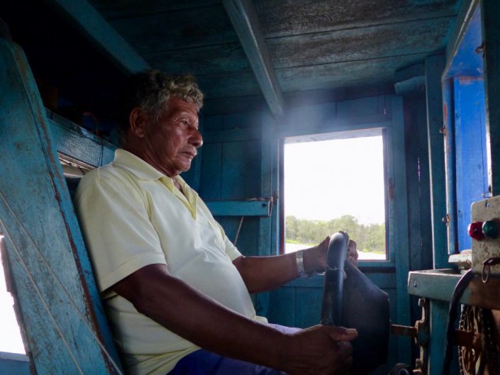
By noon the next day, we boarded a Lancha boat named Garota Viseu (Viseu Girl). Local shipwrights craft these two-decker boats of about 50 feet in length, primarily to carry cargo and people from port to port.  Today it will carry us into one of the most remote estuaries in the 250-mile coastline of this enormous mangrove and beach landscape.  Our captain, 78-year-old Benedicto, with one crew navigated the coffee- colored Gurupi, a long river that cuts deep into the tropical coastline.

A nearly completed boat in a ship yard in Viseu.

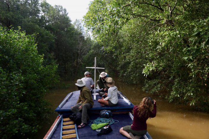
Bene took his craft down the Gurupi within sight of the wind-tossed Atlantic Ocean.  The trade winds blow constantly here, almost always at near gale levels.  But then he turned into a small channel directly into the steamy mangrove forest.  At first the path was wide, lined with a dense tangle of mangrove on either side.  Whimbrels, scarlet ibis, semi-palmated sandpipers clung to tangles of roots as the high tide flooded the soft mud.

Captain Benedicto piloting his Lacho boat, the Garota Viseu.

Then he took the boat in a channel so narrow, the crew had to duck the whipsaw of mangrove branches.  We slowly snaked our way through a tunnel of green until we reached another wide channel.  Within a few minutes, we entered another narrow channel ultimately reaching the next bay.  Here we felt the full force of the stiff winds and deep rolling swell of the Atlantic.  An hour later we weighed anchor at the small community of Apiu Salvadore.

The Garota Viseu weaves its way through the narrow mangrove passage. Stephanie Feigin, Danille Paluto, Christophe Buiden and Yann Rochepault watch from the top deck of the boat.


Few people from the outside world come to this community of about 50 ramshackle huts and cabins and about 150 people. As the boat neared the shore with most of the team standing on the roof of the boat, scattered groups of the town’s people stood on the sandy bluffs overlooking the harbor as though we just landed from space.  Ultimately, we found them welcoming but wary.  Little good comes from the outside to these communities.


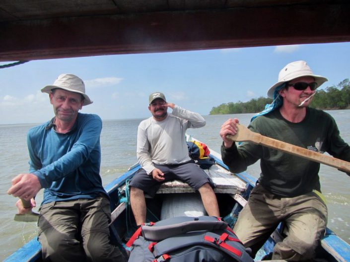
Over the next two days, we plied our craft of field biology. We needed to find small boats to take teams to the various shorebird habitats previously determined on our maps. Local craftsmen build these boats. Running about 20 feet in length, they use 10 to 20 horse power engines meant for something like a lawn tractor. Instead of driving a blade, the craftsmen power a long shaft that ends in a 8-inch propeller. The skipper can lift the engine and propeller according to the water’s depth. They suited our needs perfectly.


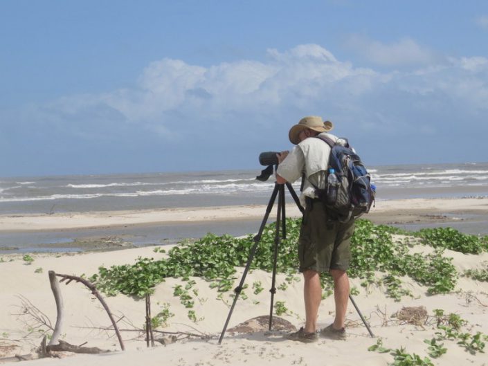
We fielded five teams in three in boats while Mandy, David Santos, Carmem and I surveyed Lombo Branco Island, about two miles from the Apiu Salvador. The sea shapes this island into a crescent, the inside protected from the restless waves.  Nestled within, one could see in miniature, the whole ecological system that creates resources for shorebirds.


At the heart of the island grows a small and stunted mangrove forest and an apicum, or wetland that only floods during lunar tides or spring tides. These are the highest of the monthly cycle of tides but only occur on the full and new moon. Every day the tide moves in and out of this small system. Twice a month the tide floods the apicum for several days at a time.

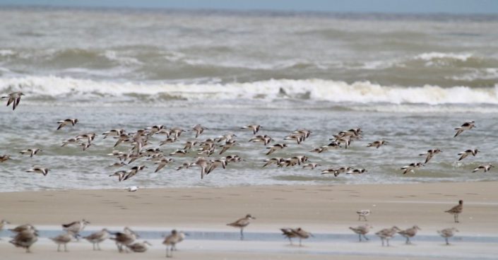
We arrived on the day of a waxing moon, near full. The very high-high tides reached well within the small drainage flooding habitats that have not been flooded in a few weeks. Shorebirds carpeted the wet mud, searching for all the invertebrate life that flourishes in this habitat. But the productivity only starts there. Here the tidal flow is gentle because the island shields it from the wind tossed Atlantic from all sides except the leeward quarter of the island. This gentle tidal flow flushes sediments from the mangrove swamp, the nutrients of the apicum and the normal productivity of a sediment-rich sandy substrate, forming the base layer of a productive food chain that nurtures small clams and other invertebrate – all prey for shorebirds.


We found whimbrels, semi-palmated sandpipers, ruddy turnstones, short-billed dowitchers, black belly plovers, willets, semi-palmated plovers, sanderlings and collared plovers.  In the lower reaches, we found 337 knots, a glorious find that will help our mapping model enormously.

Red knots, sanderlings, short billed dowitchers and other shorebird forage in the inter-tidal estuary of Morro Branco.

The following day we surveyed a second island, Coroa Criminosa. Why the sinister name we cannot say, but it supported a very similar esturary giving us another successful day. When the tide went out the small island of about 6 kilometers grew to over 20 kilometers. Intertidal sand flats spread out of sight in nearly all directions.


We left the island that night and arrived in Viseu just before dark. Once again we suffered the sway of the Atlantic. After weaving our way back through the mangrove and up the Gurupi River, we landed too late to go on.  We were thankful for the modest rooms with showers, a good meal and beer!


https://youtu.be/zLW4iRr_EI4


Dr. Larry Niles has led efforts to protect red knots and horseshoe crabs for over 30 years.


Shorebird Expedition Brazil: Conducting a scientific investigation in a tropical wilderness

By Larry Niles, LJ Niles Associates LLC

It’s hard to imagine the difficulties of people living here at Latitude 37 Degrees North when arriving at the equator in northern Brazil. It challenges even the hardiest of biologists. However, after three days our team has not only acclimated but we accomplished surveys in two separate estuaries.


Ruddy turnstone multiyear flight recorded by a geolocator caught in Maranhoa, Brazil.


Low tide was cut short on our first day in the field, while high tide persisted longer than we expected which challenged our surveying since it must take place when birds forage. Shorebirds typically forage until 1 to 2 hours before high tide and start again 1 to 2 hours after high tide, usually resting and digesting the food consumed at the lower tides. Because we intend to understand the foraging habitats of shorebirds in the wintering area, we must focus on the lower tides. This is always difficult due to logistical issues such as renting boats, equipment failures, and long distance from the ports present an array of complications. Still, we were able to go out in the field and collect some data.


The next day we did marginally better, each team member faced different problems. Our boat engine failed and we had to paddle back to port, another boat took so long to get to the shoal we intended to survey that it had already been covered by the tide.  But this is the nature of field work anywhere.


Yann and Christophe paddle our boat back to port after the engine failed.


No matter the complication, it is important to stick to our rigid protocols.  Our goal is to determine the best places for shorebirds in this area. We must work with the shorebird’s behavior because each tidal stage creates different value.  In a wild place such as this, they will choose to roost as close to the foraging areas as possible. In fact most will just roost then feed as the tide recedes then feed as the tide rises and then roost again.  So locating the feeding areas will usually indicate the roosting areas.


But things can go awry. In human dominate habitats like New Jersey, birds find it hard to roost near foraging areas. Most often the high tide forces them into people jogging, dog walking or enjoying flushing shorebirds.  So the shorebirds must leave, unnecessarily burning valuable fuel and suffering greater danger from avian predators.


The night-time roost creates the real threat here in Brazil and everywhere. At night many dangers lurk.  Ground predators, such as owls, feral cats, raccoons, and even people will take advantage of any unwary or sickened bird.  It is worse when birds are forced to use areas that are less secure than others. This can happen naturally at spring tides, for example, when the very highest high tides force them closer to the dangers lurking in the dunes or mangrove forests.  In places like Hereford, New Jersey, people often force birds to use more dangerous areas.


Larry Niles surveying.


So our goal here is to map all the areas of importance – foraging, day-time roosts and night-time roosts.  But we hope to do it with remote sensing; satellite maps that are trained by a mathematical model, that are, in turn, trained by our field data.  We count birds, photograph the surrounding habitats, precisely locate the sites, and even look at the substrate.  Is it mud, sand, muddy sand, sandy mud and so on?


Doing this in New Jersey is difficult.  Doing it in the northern coast of Brazil presents untold challenges.  One cannot easily access the coast here.  We have to rent boats to take us out to the birds, conduct surveys then get back before dark.  Sometimes we go out for days and stay in remote fishing villages, sometimes with only a floor to sleep and no facilities or power. Imagine unrelenting heat, mosquitoes, persistent blowing sand, copious sweat, and trying to conduct a scientific investigation. That would be demanding in any environment.


So this is the challenge of our crew – and they do it aplomb!  Last year one of the boats sank in 55 feet of water 8 miles out to sea. We all made it to land safely but we lost much of our equipment. The day after was grim, wondering if we should we go on or go home?  Without hesitation, not only did the crew go on to complete the survey but we ended up capturing twenty-two geolocators from ruddy turnstones tagged two years earlier. A good crew is hard to put together and stay productive in these conditions. A good spirit is the most important thing.


Our team chooses areas for the next day’s surveys. Beer is essential!


So we completed two days of surveys at the western end of our 150 miles long study area. Today we prepare for three days out to a remote area, accessible by boat only.  As I write, the team prepares for food, water and all the necessities of spending three days with minimum comfort.  We hope to camp in a fishing village, maybe a house, but we won’t know until we get there. We must prepare for all possibilities.


Our understanding of the inner workings of the Brazilian Extractavista reserve system grows every day. This system I believe holds great hope for us in the United States because it serves both the wildlife and fish and the people living in the landscape.  Pretend, for example, on Delaware Bay, the rural towns and the residents get first crack at the sustainable management of resources, not the companies exploiting them without regard to the future, as it is now. Instead of few people earning a good living off Delaware Bay resources, many would. Rural American would be transformed. This is what ICMBio hopes to achieve in this much poorer area.


Two members of our team are managers of the seven reserves in Para, our study site. They told us, for example, ICMBio (Chico Mendes institute), the federal agency in charge of the extractive reserves, pays a subsidy for local fishermen in exchange for helping manage the fishery resources. But the subsidy is limited to existing residents, not people within new reserves because of the new conservative government. One can see right away the challenges of two people managing seven reserves covering a coastline the size of New Jersey. Budget cuts have taken away all equipment funds. They must even clean their own offices as most nonessential staff has been cut under the new conservative government, a government accused of unfairly deposing the most popular liberal party.


This should resonate in the United States because it could be coming soon to a wildlife reserve near you.


Wintering knots in roost.

Dr. Larry Niles has led efforts to protect red knots and horseshoe crabs for over 30 years.


Shorebird Expedition Brazil: Investigating the plight of shorebirds and rural people

By Larry Niles, LJ Niles Associates LLC

We leave a cold and dark New Jersey with mixed feelings for our destination to tropical Brazil. It will be warm and sunnyish – though forecasts predict drenching thunderstorms threatening us every day of our trip. We will explore a very new place, the ocean coast of Para, a largely unsurveyed coast known to be a wintering shorebird mecca. At the same time, we will undergo trials experienced by few biologists. Zika is prevalent in Para, but recent cases of malaria are equally alarming.  Of course, one must be ever vigilant for food and water pathogens. Last year, I developed food poisoning ending me up in a rural hospital, with a room full of very sick people. On arrival, I wondered what comes next?


A small part of the sprawling city of Sao Jose de Ribamar.


The contrast of poverty and the truly wild can jar a Jersey biologist’s sensibility.  People fall into poverty here because it’s the common condition.  Poor sanitation, terrible roads, and nearly non-existing law enforcement plague those who live in coastal Brazil.  The economic crisis and the ever-expanding corruption scandal in the federal government rob people of hope for the future and anchor them to a life of poor education and wages, and widespread filth.  In the cities, the water churns with rubbish and contamination is ubiquitous.


Yet few people populate the ocean coast sites where we will survey.  There, the sea teams with fish and shellfish beyond measure.  Walking through a fish market is like going to a fish museum for all the species, exotic and common.  Hundreds of small villages, most with only occasional power, perch precariously on the edge of this wonderful and largely uncontaminated sea or nestle deep in a vast mangrove forest, one of the largest in the world.  In many ways it’s a biologist’s wonderland.


Our team walks through a small fishing village in the Brazilian state of Maranhao. The village has no power system just a generator that turns on in the evening for a few hours.


Only a few hundred miles away snakes the many channels of the Amazon River and surrounding it lies one of the world’s last great tropical forests.  It’s the home of one of the great battlegrounds of environmentalism.  The new U.S. administration will probably support the wealthy families cutting away valuable timber for cattle ranching, destroying carbon capturing and oxygen producing trees and, at the same time, the livelihood of native people who eke out a bare existence from rubber, nuts and the diverse wildlife that share the forest with them.


An illegal forest cut in the Brazilian rainforest in the state of Para.


But our government has a lot to learn from the Brazilians. They have created a novel conservation system, one unknown to us in the U.S.


They call them extractive reserves. The federal agency in charge, ICMBio, struggles to save these reserves, not for tourists or rich residents, as we do in New Jersey, but for the people who live within.  They stop the ranchers from destroying the forest. In the same way, they stop the international fishing fleets from decimating the fishery in Para. Staff of the agency die every year doing their job. One just recently in the state of Para, not far from our destination.


There are seven extractive reserves in our coastal study site in Para, Brazil. This map was created by Dan Merchant and Rick Lathrop CRSSA.


Our project aims to help. Our team, sponsored by Conserve Wildlife Foundation with Neotropical Migratory Bird Conservation Act, will survey birds, measure habitat, and ultimately map this coast with state-of-the-art GIS system developed by Rutgers Center for Remote Sensing and Spatial Analysis.  We intend to provide ICMBio staff with better GIS tools than are available in the U.S.


Over the next three weeks, we will be reporting on our research investigation. We will also explore the threats to the extractive reserves in our study area, everything from disturbance to shrimp farms.


For my part, however, I will also investigate if this system captures the best conservation envisaged by most religious leaders, including Pope Francis. Despite the political rhetoric of the old politicians that fill our media, most of the world’s religions speak openly about supporting climate change action. They envisage an “integral ecology”, in the word of Pope Francis, a union of the need to heal the earth and the plight of the poor.  Even Southern Baptist have adopted this position that the impact of climate change falls on the poor.  This is as true in Brazil as it is in Delaware Bay.  Perhaps in Brazil lies a better way.


Dr. Larry Niles has led efforts to protect red knots and horseshoe crabs for over 30 years.


Volunteers and biologists add the next oyster reef to Dyers Cove

Team works through threat of downpour to strengthen Delaware Bay’s resiliency and ecology

By Emily Hofmann, Project Coordinator


Although the weather was on the brink of being rainy and bleak, that did not stop a team of dedicated biologists and volunteers from building an oyster reef on the Delaware Bayshore this past Saturday. Committed volunteers and young people braved the weather to work alongside American Littoral Society and Conserve Wildlife Foundation to build a near-shore oyster reef at Dyers Cove, at the end of Dyers Creek Road in Newport, Cumberland County, New Jersey.


oyster-reef-2

This reef – like the one at South Reeds Beach – was built to protect restoration work done after Hurricane Sandy and provide habitat. Constructed to prevent sand loss from wind-driven waves and create calmer water for spawning horseshoe crabs, this is the third of five such reefs that have been built by the Littoral Society and CWF. The conservation organizations will continue to monitor whether the reef breakwaters help reduce beach erosion and create calmer water for spawning horseshoe crabs.


Due to the heavy rain over the course of the week, the conditions were not ideal. Low-tide never went below waist deep, so it was hard to construct the reef accordingly. But that did not stop the team!oyster-reef-build_5


“Every oyster reef we’ve built so far on the Delaware Bay incorporated a different restoration strategy. We have had to adapt new strategies with what has worked best in the past and with what will realistically work based on site conditions. By blending the successes from the previous reefs with innovative approaches, we have been able to construct three reefs to date,” said Capt. Al Modjeski, Habitat Restoration Program Director for the American Littoral Society.


The bayshore beaches need restoration and improved resiliency so that horseshoe crabs have proper breeding grounds. Crab eggs feed migratory shorebirds, like the Red Knot, which stops in New Jersey each spring on its long journey from South America to the Arctic Circle. The Red Knot and other shorebirds help bring $11 million in tourist dollars to New Jersey’s Delaware Bayshore region each year.


“New Jersey’s Delaware Bayshore hosts an annual wildlife spectacle of global significance – the time-honored migration of Red Knots to reach the eggs of these ancient horseshoe crabs,” said David Wheeler, Conserve Wildlife Foundation of New Jersey Executive Director. “Volunteer projects like this help connect the people of New Jersey with these endangered shorebirds and the largest population of horseshoe crabs in the world.”


“Originally, this event was a bare-bones volunteer effort of placing shell bags off the Dyers Cove eastern beach,” said Capt. Al. “But thanks to a donation from Betancourt, Van Hemmen, Greco & Kenyon, we will have a ‘shell-a-bration’ that celebrates the ecology and community of the Delaware Bayshore.”

oyster-reef

In 2015, over 130 volunteers and veterans built an oyster reef at South Reeds Beach in the first annual Shell-a-Bration. That same year, Veterans Day on the Bay dedicated the reef to all veterans and highlighted veteran involvement in the effort to restore New Jersey’s Delaware Bayshore. The second annual Shell-a-Bration, held in April 2016, saw a handful of dedicated volunteers brave a blizzard to build a reef at Moore’s Beach. The third annual Shell-Bration will be held this coming Spring 2017.


“There are many strategies to defend our Delaware Bayshore, but one of the best and most productive are these oyster reefs,” stated Dr. Larry Niles, a biologist with the American Littoral Society and Conserve Wildlife Foundation of New Jersey. “They not only replicate a lost but important habitat on Delaware Bay – reefs once covered much of the bayshore – but they provide just enough protection to make a difference in how long our beaches persist against the unrelenting forces of nature. In a way, we are fighting nature with nature.”

oyster-reef-4

The projects are being funded by National Fish and Wildlife Foundation (NFWF) through their Hurricane Sandy Coastal Resiliency Grants Program, and are being developed in partnership with U.S. Fish and Wildlife Service and New Jersey Division of Fish and Wildlife.


Emily Hofmann is a project coordinator for Conserve Wildlife Foundation


LEARN MORE


New Jersey’s Hidden Coast – The Final Episode

NEW JERSEY’S HIDDEN COAST – EPISODE 6

by Emily Hofmann, Assistant Communications Manager


“Our work on the bayshore is not just about wildlife, it’s about people, and how keeping nature strong keeps us all strong in the face of disasters like hurricanes.”


We want to ensure that New Jersey’s Hidden Coast remains a vital part of our livelihood for generations to come.


This is the final episode to our video series, “New Jersey’s Hidden Coast.” Catch a glimpse of the Bay, the horseshoe crab at the center of the bay’s system, and the incredible relationship between horseshoe crabs and migratory birds, like the red knot. We reveal the real value of horseshoe crabs, the challenges to the ecosystem, and the potential for thriving regional economy along the bayshore. We will show Hurricane Sandy as a catalyst for decisive action and the work being done to rebuild the area for both people and wildlife.


Catch up on the previous episodes, here on our blog or on YouTube. Explore the use of “living shorelines” instead of bulkheads and the importance of marshes to the marine ecosystem. Discover the on-the-ground, grassroots efforts of the community to build oyster reeds alongside veterans. And examine the future of the Bay and the work that needs to be done to preserve our conservation successes year after year.


Discover Delaware Bay:


New Jersey’s Hidden Coast – Strengthening Bayshore Beaches

NEW JERSEY’S HIDDEN COAST – EPISODE 5

By Emily Hofmann, Assistant Communications Manager


Like all ecosystems, Delaware Bay is amazingly complex, and there’s no one way to fix it. Between climate change, sea level rise, and the growing risk of major storms, there’s a lot to consider.


We’ve learned that restoring healthy marsh habitat is a key component in rebuilding Delaware Bay beaches; however, we’re also trying to further strengthen bayshore beaches by building reefs – living underwater infrastructure. By creating some reef structures we can keep the sand where we’re putting it.


Learn more about strengthening New Jersey’s Hidden Coast – the Delaware Bayshore in our fifth episode to our series.


A new episode of our video series “New Jersey’s Hidden Coast” will air every two weeks throughout the summer! Catch a glimpse of the bay, the horseshoe crab at the center of the bay’s system, and the incredible relationship between horseshoe crabs and migratory birds, like the red knot. We will reveal the real value of horseshoe crabs, the challenges to the ecosystem, and the potential for a thriving regional economy along the Bayshore. We will show Hurricane Sandy as a catalyst for decisive action and the work being done to rebuild the area for both people and wildlife.


Over the next several weeks, we will explore the use of “living shorelines” instead of bulkheads and the central importance of marshes to the marine ecosystem. We will discover the on-the-ground, grassroots efforts of the community to build oyster reefs alongside veterans. And we will examine the future of the Bay and the work that needs to be done to preserve our conservation successes thus far.


Discover Delaware Bay:


Healthy Marshes, Healthy Beaches

NEW JERSEY’S HIDDEN COAST – EPISODE 4

By Emily Hofmann, Assistant Communications Manager

Periodic storms are an unavoidable fact of life when you live along the coast. In rebuilding after Hurricane Sandy, we realized we needed a new way of thinking about beach restoration on New Jersey’s Hidden Coast – the Delaware Bayshore. Storms like Sandy and Katrina have shown us that the most effective way to control storm surge is to follow Mother Nature’s lead. The restoration of tidal wetlands, or marshes, will help absorb the brunt of coastal storms, acting as a buffer between the beaches and the mainland.


Learn more about marsh restoration – one of the key components to rebuilding coastal beaches – in the fourth episode of our video series.


A new episode of our video series “New Jersey’s Hidden Coast” will air every two weeks throughout the summer! Catch a glimpse of the bay, the horseshoe crab at the center of the bay’s system, and the incredible relationship between horseshoe crabs and migratory birds, like the red knot. We will reveal the real value of horseshoe crabs, the challenges to the ecosystem, and the potential for a thriving regional economy along the Bayshore. We will show Hurricane Sandy as a catalyst for decisive action and the work being done to rebuild the area for both people and wildlife.


Over the next several weeks, we will explore the use of “living shorelines” instead of bulkheads and the central importance of marshes to the marine ecosystem. We will discover the on-the-ground, grassroots efforts of the community to build oyster reefs alongside veterans. And we will examine the future of the Bay and the work that needs to be done to preserve our conservation successes thus far.


Discover Delaware Bay:


New Jersey’s Hidden Coast — After the Storm

New Jersey’s Hidden Coast — Episode 3

by Lindsay McNamara, Communications Manager

At 8:00 PM on October 29th, 2012, Hurricane Sandy made landfall in Brigantine, New Jersey, only about 30 miles from New Jersey’s Hidden Coast – the Delaware Bayshore. The storm was devastating for the people of the area, many of whom lost their homes and livelihoods. It was equally hard on the area’s wildlife, bringing many species, including the famous horseshoe crab and red knot, perilously close to extinction.


What happened? Watch the story unfold in the third episode of our video series.


A new episode of our video series “New Jersey’s Hidden Coast” will air every two weeks throughout the summer! Catch a glimpse of the bay, the horseshoe crab at the center of the bay’s system, and the incredible relationship between horseshoe crabs and migratory birds, like the red knot. We will reveal the real value of horseshoe crabs, the challenges to the ecosystem, and the potential for a thriving regional economy along the Bayshore. We will show Hurricane Sandy as a catalyst for decisive action and the work being done to rebuild the area for both people and wildlife.


Over the next several weeks, we will explore the use of “living shorelines” instead of bulkheads and the central importance of marshes to the marine ecosystem. We will discover the on-the-ground, grassroots efforts of the community to build oyster reefs alongside veterans. And we will examine the future of the Bay and the work that needs to be done to preserve our conservation successes thus far.


Discover Delaware Bay:


Lindsay McNamara is the Communications Manager for Conserve Wildlife Foundation of New Jersey.


The Real Value of Horseshoe Crabs

New Jersey’s Hidden Coast – Episode 2

by Lindsay McNamara, Communications Manager

Horseshoe crabs may be one of the most unusual animals in the world, but they’re also one of the most extraordinary. They’ve been around for hundreds of millions of years, and we’re only now starting to understand just how important they are – not just to the natural world, but also to the world of medicine. Discover the real value of horseshoe crabs, found throughout New Jersey’s Hidden Coast – the Delaware Bayshore.


A new episode of our video series “New Jersey’s Hidden Coast” will air every two weeks throughout the summer! Catch a glimpse of the bay, the horseshoe crab at the center of the bay’s system, and the incredible relationship between horseshoe crabs and migratory birds, like the red knot. We will reveal the real value of horseshoe crabs, the challenges to the ecosystem, and the potential for a thriving regional economy along the Bayshore. We will show Hurricane Sandy as a catalyst for decisive action and the work being done to rebuild the area for both people and wildlife.


Over the next several weeks, we will explore the use of “living shorelines” instead of bulkheads and the central importance of marshes to the marine ecosystem. We will discover the on-the-ground, grassroots efforts of the community to build oyster reefs alongside veterans. And we will examine the future of the Bay and the work that needs to be done to preserve our conservation successes thus far.


Discover Delaware Bay:


Lindsay McNamara is the Communications Manager for Conserve Wildlife Foundation of New Jersey.

A Job Well Done!

One in a Series of Updates on the 20th Year of the Delaware Bay Shorebird Project

by Dr. Larry Niles, LJ Niles Associates LLC

On our final effort to trap shorebirds on Delaware Bay, we had the remarkable opportunity to watch sanderling and ruddy turnstones lift off for the Arctic. We first saw them feeding on the wave-tossed shoreline within the protected area in Villas; 1500 birds weaving as a single thread 5 deep with the contours of the wave, acting like a flying flock on the ground. Then a disturbance, a crow flying low down the shoreline and 2000 birds fill the sky.  Most settled again but one group of about 300 flew more with greater determination than the rest. Still low but gaining altitude the flock wavered, and a mutinous band peeled away deciding against the departure returned to the safety and abundant crab eggs on the shore just north of us.  The other 150 grew more determined, more structured and rose slowly as they powered their way north. Then they disappeared into the Northern sky.

shorebirds flying for the Arctic
A flock of shorebirds seen from Reeds Beach venture into the northern horizon for a nonstop flight to the Canadian Arctic.


Shorebirds departing Delaware Bay for their Arctic home, 2500 miles away stand as one of the most awe-inspiring and rewarding parts of our stopover project. They usually start in the early evening under a blue sky drenched with the glow of the setting sun and continue until near dark.  They almost always go with a favorable southerly breeze and at least a clear sky in the north.  Thousands of all the species after getting fat on the Bay’s bounty of horseshoe crab eggs – red knots, ruddy turnstones, sanderling, semipalmated sandpipers, short-billed dowitchers and dunlin –  lift slowly as they fly along the Cape May peninsula coast towards Dennisville and beyond.

Viable Migration Departures_2016
Led by Clive Minton, the team counts the number of flocks and flock size from our porch on Reeds Beach. This is only an index, as birds leave after daylight and from other places in the bay.


They are dangerously overloaded with fat. Two birds highlighted the importance of this.  On May 30 we caught 97 knots, 168 sanderlings and 75 ruddy turnstones.  Among each species were individuals of extraordinary weight.  One bird weighed 242 grams, fully 120 grams higher than the fat free weight!  They cart this load, like a plane with extra gas tanks, to fly two days to the Arctic islands of Canada.   Imagine for a moment – you weigh 150 pounds and gain an extra hundred and fifty, then try to go anywhere, especially for 2000 miles.


In this video one can see all the different body shapes – and weights – of red knots and other species on Cooks Beach shoal.   It’s easy to see many birds are ready to leave.


The fact that they can do this is a marvel of flight bio-engineering.  While building weight they prepare like weight lifters, increasing muscle mass, heart size, and lung capacity.  Close to leaving, they decrease the organs of digestion just to squeeze in the last few grams of fat.  Then they wait for good weather, lumber into the sky and go forth into the vast north.


2016 was a good year for the shorebirds stopping over on the New Jersey coast. Most came in better-than-average condition, so they had a head start.  The early spawn was strangled by cold water which seemed to hover around the temperature threshold for spawning- 59 degrees F.  Tellingly however, the crabs spawned with gusto on the beaches from northern Reeds to Pierce’s Point. There the five inter-tidal creeks and inter-tidal flats warm the water that washes over spawn-inviting shoals and newly restored beaches.  Throughout the stopover a majority of the bay’s population foraged on the eggs laid by vigorously spawning horseshoe crabs.  On one day we saw a 10,000 red knot flocks on North Reeds Beach happily roosting and feeding on the abundant eggs.


red knots on north reeds
In this iPhone panorama of north reeds beach one could see over 8000 red knots feeding on abundant crab eggs.
crabs spawning on Villas
Spawning crabs on Villas beach


Eventually the spawn accelerated and expanded but the birds still needed to get to the eggs.  If constantly disturbed by people, they will move endlessly often to lesser habitat if only to avoid disturbance.  In New Jersey we prevent this. Each year for the last 15 years, the New Jersey Division of Fish and Wildlife in collaboration with Conserve Wildlife Foundation of New Jersey, close the beaches important to crabs while leaving small observation areas open to the public.  The impact is non-intuitive but positive.

Jim May stewarding kimbles beach
Neil Olafsson saving a crab stucked on a derelict bulkhead
Jim May (first photo) and Niel Olafson (second photo) have been stewarding beaches for over 10 years. Stewards not only defend beaches from the few people determined to breach the rope barriers, but bring their own outreach materials to educate people on the importance of stewardship. They also rescue stranded crabs in tough spots like abandoned bulkheads.


The closed beaches allow shorebirds to gorge on eggs unmolested by people: photographers and birders wanting to get one step closer for the perfect picture, compassionate people wanting to overturn crabs left stranded by the tide, or fishermen wanting to cast for the stripers that run in May.  All with good intentions they scatter birds and force them to fly to other less suitable and less accessible beaches losing valuable gained weight in the process.   The closures allow the birds to stay in the best places and eat like kings.  Paradoxically the bird photographers and watchers end up with even better views because the birds adapt to the settled threat. Even fishermen find enough space to fish from the observation areas.

person disturbing shorebirds with dog
This person is unaware that her impact has cleared the area of shorebird leaving all the eggs to laughing gulls, who as we all know fear no human.


At the height of the season people could come to one of the five observation areas in the Reeds, Pierce’s Cove and see flocks of nearly 30,000 shorebirds including 14,000 red knots – two thirds of the  whole population in the bay this year (as determined by air and ground counts).  Photographers, birders and inquisitive people had a wonderful experience and the birds got fat.


Despite the difficulties caused by the unusually cold spring, most birds of the three species we follow reached good departure weights and by May 26th they started to leave. By June 1st most were gone and by June 2nd we advised reopening the beaches, 5 days earlier than the usual June 7th opening.

weight graphs


Our team of scientists, managers, students, volunteers, and stewards deserve praise for all the various projects and research conducted throughout the season, from cannon netting and bird study, resightings of previously banded birds, research on shorebird movement, research on oyster reefs and structural aquaculture, monitoring of horseshoe crabs, monitoring crab egg densities, volunteer efforts to rescue stranded crabs, to steward protected areas and tag crabs. Also, the volunteers of Citizens United to Protect the Maurice River deserve a special thanks for their logistical support for our team, they prepared over 20 dinners for 30 plus people every night of our project.  Birds and Scientists all gain weight in May!


They all deserve gratitude, from the birds and horseshoe crabs, the people who love birds and horseshoe crabs and the people who love Delaware Bay.


2016 shorebird project team ( without phil's correction)
The 2016 shorebird team


Dr. Larry Niles has led efforts to protect red knots and horseshoe crabs for over 30 years.